You are here: Home > Network List > TA - USArray Transportable Network (new EarthScope stations) Stations List
> Station H38A Maiden Rock, WI, USA > Earthquake Result Viewer
H38A Maiden Rock, WI, USA - Earthquake Result Viewer
| Earthquake location: |
Central Peru |
| Earthquake latitude/longitude: |
-13.8/-72.3 |
| Earthquake time(UTC): |
2013/05/21 (141) 23:02:45 GMT |
| Earthquake Depth: |
92 km |
| Earthquake Magnitude: |
5.8 MW, 5.7 MB, 5.8 MW |
| Earthquake Catalog/Contributor: |
NEIC PDE/NEIC PDE-W |
|
| Network: |
TA USArray Transportable Network (new EarthScope stations) |
| Station: |
H38A Maiden Rock, WI, USA |
| Lat/Lon: |
44.68 N/92.28 W |
| Elevation: |
333 m |
|
| Distance: |
61.0 deg |
| Az: |
343.779 deg |
| Baz: |
157.641 deg |
| Ray Param: |
0.060927995 |
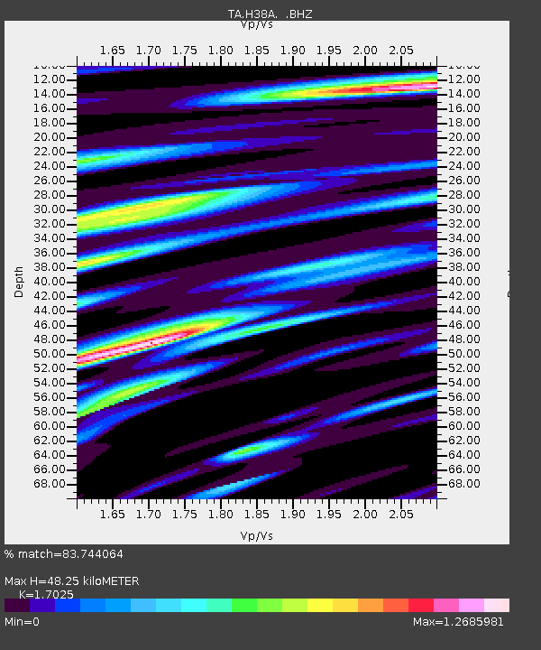
| Estimated Moho Depth: |
48.25 km |
| Estimated Crust Vp/Vs: |
1.70 |
| Assumed Crust Vp: |
6.571 km/s |
| Estimated Crust Vs: |
3.859 km/s |
| Estimated Crust Poisson's Ratio: |
0.24 |
|
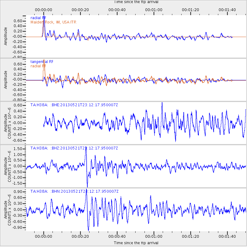
| Radial Match: |
83.744064 % |
| Radial Bump: |
400 |
| Transverse Match: |
71.22917 % |
| Transverse Bump: |
400 |
| SOD ConfigId: |
512894 |
| Insert Time: |
2013-09-14 15:23:32.467 +0000 |
| GWidth: |
2.5 |
| Max Bumps: |
400 |
| Tol: |
0.001 |
|
Signal To Noise
| Channel | StoN | STA | LTA |
| TA:H38A: :BHZ:20130521T23:12:17.950007Z | 3.313238 | 3.01215E-7 | 9.091258E-8 |
| TA:H38A: :BHN:20130521T23:12:17.950007Z | 1.9871864 | 2.8093186E-7 | 1.4137167E-7 |
| TA:H38A: :BHE:20130521T23:12:17.950007Z | 1.3150617 | 1.5728915E-7 | 1.1960591E-7 |
| Arrivals |
| Ps | 5.4 SECOND |
| PpPs | 19 SECOND |
| PsPs/PpSs | 24 SECOND |


