You are here: Home > Network List > TA - USArray Transportable Network (new EarthScope stations) Stations List
> Station K40A Colesburg, IA, USA > Earthquake Result Viewer
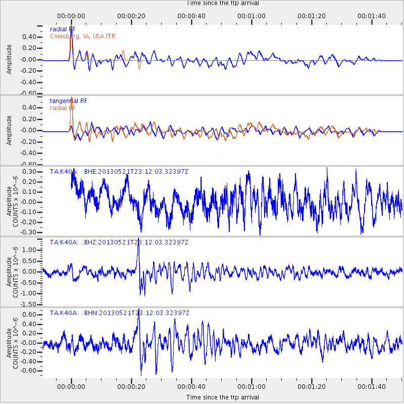
K40A Colesburg, IA, USA - Earthquake Result Viewer
*The percent match for this event was below the threshold and hence no stack was calculated.
| Earthquake location: |
Central Peru |
| Earthquake latitude/longitude: |
-13.8/-72.3 |
| Earthquake time(UTC): |
2013/05/21 (141) 23:02:45 GMT |
| Earthquake Depth: |
92 km |
| Earthquake Magnitude: |
5.8 MW, 5.7 MB, 5.8 MW |
| Earthquake Catalog/Contributor: |
NEIC PDE/NEIC PDE-W |
|
| Network: |
TA USArray Transportable Network (new EarthScope stations) |
| Station: |
K40A Colesburg, IA, USA |
| Lat/Lon: |
42.70 N/91.14 W |
| Elevation: |
274 m |
|
| Distance: |
58.8 deg |
| Az: |
343.815 deg |
| Baz: |
158.447 deg |
| Ray Param: |
$rayparam |
*The percent match for this event was below the threshold and hence was not used in the summary stack. |
|
| Radial Match: |
68.84213 % |
| Radial Bump: |
400 |
| Transverse Match: |
44.78378 % |
| Transverse Bump: |
400 |
| SOD ConfigId: |
512894 |
| Insert Time: |
2013-09-14 15:25:11.970 +0000 |
| GWidth: |
2.5 |
| Max Bumps: |
400 |
| Tol: |
0.001 |
|
Signal To Noise
| Channel | StoN | STA | LTA |
| TA:K40A: :BHZ:20130521T23:12:03.32397Z | 3.00134 | 2.5986785E-7 | 8.6583945E-8 |
| TA:K40A: :BHN:20130521T23:12:03.32397Z | 1.3119637 | 1.2533089E-7 | 9.552924E-8 |
| TA:K40A: :BHE:20130521T23:12:03.32397Z | 1.3834586 | 1.551631E-7 | 1.1215593E-7 |
| Arrivals |
| Ps | |
| PpPs | |
| PsPs/PpSs | |


