You are here: Home > Network List > TA - USArray Transportable Network (new EarthScope stations) Stations List
> Station K42A Prairie Point, Evansville, WI, USA > Earthquake Result Viewer
K42A Prairie Point, Evansville, WI, USA - Earthquake Result Viewer
| Earthquake location: |
Central Peru |
| Earthquake latitude/longitude: |
-13.8/-72.3 |
| Earthquake time(UTC): |
2013/05/21 (141) 23:02:45 GMT |
| Earthquake Depth: |
92 km |
| Earthquake Magnitude: |
5.8 MW, 5.7 MB, 5.8 MW |
| Earthquake Catalog/Contributor: |
NEIC PDE/NEIC PDE-W |
|
| Network: |
TA USArray Transportable Network (new EarthScope stations) |
| Station: |
K42A Prairie Point, Evansville, WI, USA |
| Lat/Lon: |
42.78 N/89.35 W |
| Elevation: |
302 m |
|
| Distance: |
58.4 deg |
| Az: |
345.296 deg |
| Baz: |
160.43 deg |
| Ray Param: |
0.0625859 |
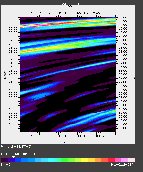
| Estimated Moho Depth: |
14.5 km |
| Estimated Crust Vp/Vs: |
1.61 |
| Assumed Crust Vp: |
6.571 km/s |
| Estimated Crust Vs: |
4.087 km/s |
| Estimated Crust Poisson's Ratio: |
0.18 |
|
| Radial Match: |
83.37547 % |
| Radial Bump: |
400 |
| Transverse Match: |
64.67529 % |
| Transverse Bump: |
400 |
| SOD ConfigId: |
512894 |
| Insert Time: |
2013-09-14 15:25:14.500 +0000 |
| GWidth: |
2.5 |
| Max Bumps: |
400 |
| Tol: |
0.001 |
|
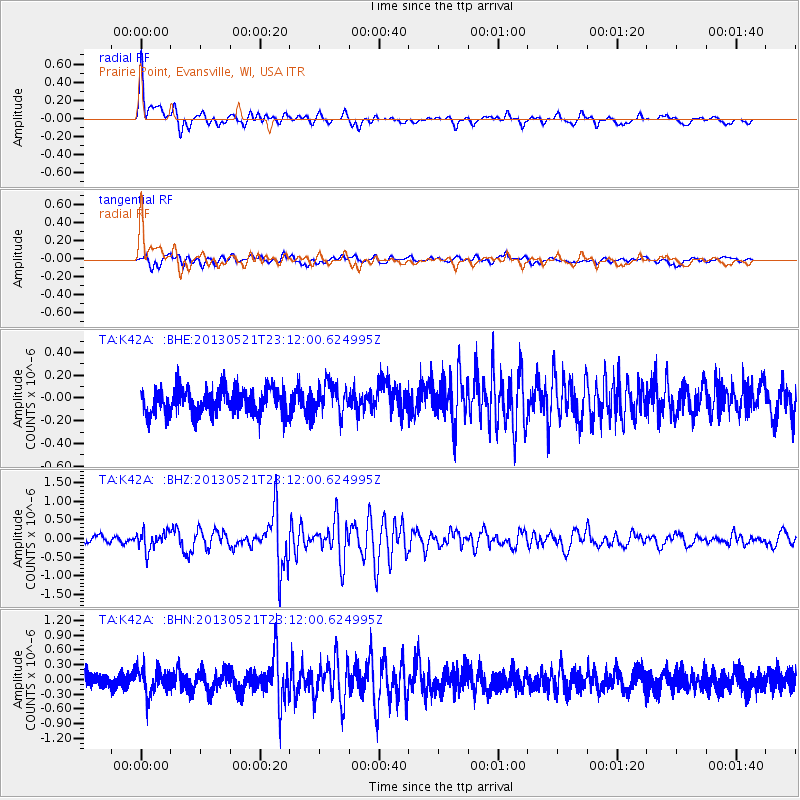
Signal To Noise
| Channel | StoN | STA | LTA |
| TA:K42A: :BHZ:20130521T23:12:00.624995Z | 2.0022643 | 2.520262E-7 | 1.258706E-7 |
| TA:K42A: :BHN:20130521T23:12:00.624995Z | 1.9189943 | 2.7308528E-7 | 1.4230646E-7 |
| TA:K42A: :BHE:20130521T23:12:00.624995Z | 1.1839201 | 1.3371947E-7 | 1.1294636E-7 |
| Arrivals |
| Ps | 1.4 SECOND |
| PpPs | 5.4 SECOND |
| PsPs/PpSs | 6.9 SECOND |


