You are here: Home > Network List > PS - Pacific21 Stations List
> Station TSK Tsukuba, Japan > Earthquake Result Viewer
TSK Tsukuba, Japan - Earthquake Result Viewer
| Earthquake location: |
Kermadec Islands, New Zealand |
| Earthquake latitude/longitude: |
-29.4/-177.4 |
| Earthquake time(UTC): |
1992/10/24 (298) 08:23:04 GMT |
| Earthquake Depth: |
41 km |
| Earthquake Magnitude: |
5.8 MB, 6.2 MS, 6.6 UNKNOWN |
| Earthquake Catalog/Contributor: |
WHDF/NEIC |
|
| Network: |
PS Pacific21 |
| Station: |
TSK Tsukuba, Japan |
| Lat/Lon: |
36.21 N/140.11 E |
| Elevation: |
350 m |
|
| Distance: |
76.6 deg |
| Az: |
325.818 deg |
| Baz: |
142.701 deg |
| Ray Param: |
0.05084576 |
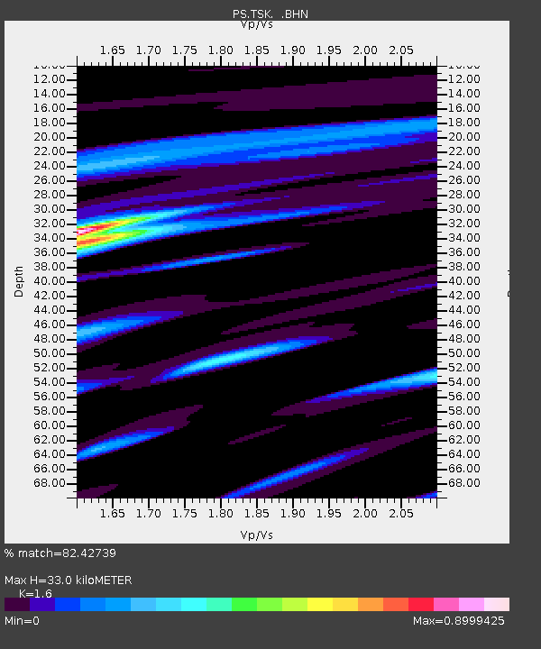
| Estimated Moho Depth: |
33.0 km |
| Estimated Crust Vp/Vs: |
1.60 |
| Assumed Crust Vp: |
6.24 km/s |
| Estimated Crust Vs: |
3.9 km/s |
| Estimated Crust Poisson's Ratio: |
0.18 |
|
| Radial Match: |
82.42739 % |
| Radial Bump: |
400 |
| Transverse Match: |
60.783566 % |
| Transverse Bump: |
400 |
| SOD ConfigId: |
16938 |
| Insert Time: |
2010-02-27 03:50:03.838 +0000 |
| GWidth: |
2.5 |
| Max Bumps: |
400 |
| Tol: |
0.001 |
|

Signal To Noise
| Channel | StoN | STA | LTA |
| PS:TSK: :BHN:19921024T08:34:19.352002Z | 1.045084 | 3.4172908E-7 | 3.2698716E-7 |
| PS:TSK: :BHE:19921024T08:34:19.352002Z | 0.5633712 | 2.815235E-7 | 4.9971226E-7 |
| PS:TSK: :BHZ:19921024T08:34:19.352002Z | 2.3779144 | 1.158355E-6 | 4.8713065E-7 |
| Arrivals |
| Ps | 3.3 SECOND |
| PpPs | 13 SECOND |
| PsPs/PpSs | 17 SECOND |


