You are here: Home > Network List > TA - USArray Transportable Network (new EarthScope stations) Stations List
> Station L53A Girard, PA, USA > Earthquake Result Viewer
L53A Girard, PA, USA - Earthquake Result Viewer
| Earthquake location: |
Central Peru |
| Earthquake latitude/longitude: |
-13.8/-72.3 |
| Earthquake time(UTC): |
2013/05/21 (141) 23:02:45 GMT |
| Earthquake Depth: |
92 km |
| Earthquake Magnitude: |
5.8 MW, 5.7 MB, 5.8 MW |
| Earthquake Catalog/Contributor: |
NEIC PDE/NEIC PDE-W |
|
| Network: |
TA USArray Transportable Network (new EarthScope stations) |
| Station: |
L53A Girard, PA, USA |
| Lat/Lon: |
41.95 N/80.26 W |
| Elevation: |
355 m |
|
| Distance: |
55.9 deg |
| Az: |
352.805 deg |
| Baz: |
170.611 deg |
| Ray Param: |
0.06418964 |
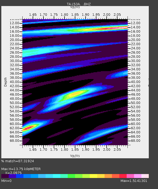
| Estimated Moho Depth: |
13.75 km |
| Estimated Crust Vp/Vs: |
2.10 |
| Assumed Crust Vp: |
6.483 km/s |
| Estimated Crust Vs: |
3.091 km/s |
| Estimated Crust Poisson's Ratio: |
0.35 |
|
| Radial Match: |
87.31924 % |
| Radial Bump: |
400 |
| Transverse Match: |
62.35911 % |
| Transverse Bump: |
400 |
| SOD ConfigId: |
512894 |
| Insert Time: |
2013-09-14 15:26:20.173 +0000 |
| GWidth: |
2.5 |
| Max Bumps: |
400 |
| Tol: |
0.001 |
|

Signal To Noise
| Channel | StoN | STA | LTA |
| TA:L53A: :BHZ:20130521T23:11:43.174006Z | 4.335271 | 3.6257737E-7 | 8.363431E-8 |
| TA:L53A: :BHN:20130521T23:11:43.174006Z | 3.6000507 | 2.2559136E-7 | 6.266338E-8 |
| TA:L53A: :BHE:20130521T23:11:43.174006Z | 1.1404525 | 9.034922E-8 | 7.9222254E-8 |
| Arrivals |
| Ps | 2.4 SECOND |
| PpPs | 6.3 SECOND |
| PsPs/PpSs | 8.7 SECOND |


