You are here: Home > Network List > PS - Pacific21 Stations List
> Station TSK Tsukuba, Japan > Earthquake Result Viewer
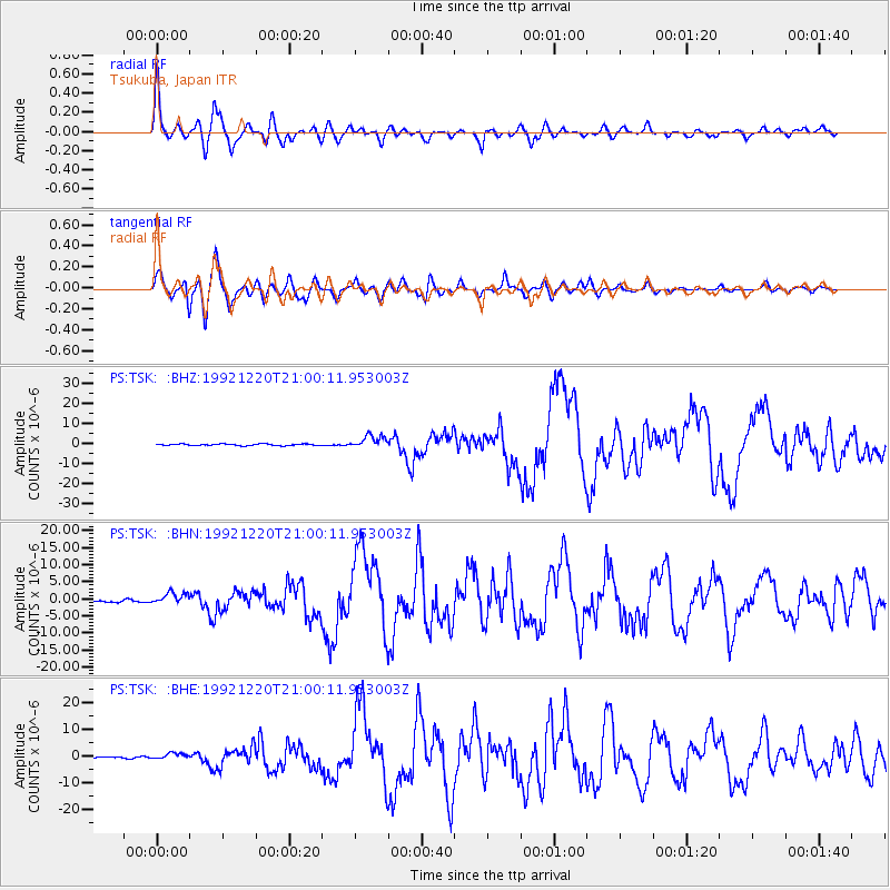
TSK Tsukuba, Japan - Earthquake Result Viewer

| Earthquake location: |
Banda Sea |
| Earthquake latitude/longitude: |
-6.5/130.4 |
| Earthquake time(UTC): |
1992/12/20 (355) 20:52:42 GMT |
| Earthquake Depth: |
33 km |
| Earthquake Magnitude: |
6.6 MB, 7.1 MS, 7.0 UNKNOWN |
| Earthquake Catalog/Contributor: |
WHDF/NEIC |
|
| Network: |
PS Pacific21 |
| Station: |
TSK Tsukuba, Japan |
| Lat/Lon: |
36.21 N/140.11 E |
| Elevation: |
350 m |
|
| Distance: |
43.5 deg |
| Az: |
11.447 deg |
| Baz: |
194.114 deg |
| Ray Param: |
0.072469056 |
| Estimated Moho Depth: |
21.25 km |
| Estimated Crust Vp/Vs: |
1.74 |
| Assumed Crust Vp: |
6.24 km/s |
| Estimated Crust Vs: |
3.597 km/s |
| Estimated Crust Poisson's Ratio: |
0.25 |
|
| Radial Match: |
94.737686 % |
| Radial Bump: |
400 |
| Transverse Match: |
91.01951 % |
| Transverse Bump: |
400 |
| SOD ConfigId: |
16938 |
| Insert Time: |
2010-02-27 03:50:23.633 +0000 |
| GWidth: |
2.5 |
| Max Bumps: |
400 |
| Tol: |
0.001 |
|
Signal To Noise
| Channel | StoN | STA | LTA |
| PS:TSK: :BHN:19921220T21:00:11.953003Z | 6.844576 | 1.7728681E-6 | 2.5901798E-7 |
| PS:TSK: :BHE:19921220T21:00:11.953003Z | 3.8168695 | 1.1654492E-6 | 3.0534167E-7 |
| PS:TSK: :BHZ:19921220T21:00:11.953003Z | 8.722769 | 3.224781E-6 | 3.6969698E-7 |
| Arrivals |
| Ps | 2.7 SECOND |
| PpPs | 8.7 SECOND |
| PsPs/PpSs | 11 SECOND |


