You are here: Home > Network List > TA - USArray Transportable Network (new EarthScope stations) Stations List
> Station P43A Skaggs, Pawnee, IL, USA > Earthquake Result Viewer
P43A Skaggs, Pawnee, IL, USA - Earthquake Result Viewer
| Earthquake location: |
Central Peru |
| Earthquake latitude/longitude: |
-13.8/-72.3 |
| Earthquake time(UTC): |
2013/05/21 (141) 23:02:45 GMT |
| Earthquake Depth: |
92 km |
| Earthquake Magnitude: |
5.8 MW, 5.7 MB, 5.8 MW |
| Earthquake Catalog/Contributor: |
NEIC PDE/NEIC PDE-W |
|
| Network: |
TA USArray Transportable Network (new EarthScope stations) |
| Station: |
P43A Skaggs, Pawnee, IL, USA |
| Lat/Lon: |
39.64 N/89.52 W |
| Elevation: |
176 m |
|
| Distance: |
55.5 deg |
| Az: |
343.867 deg |
| Baz: |
159.536 deg |
| Ray Param: |
0.064459965 |
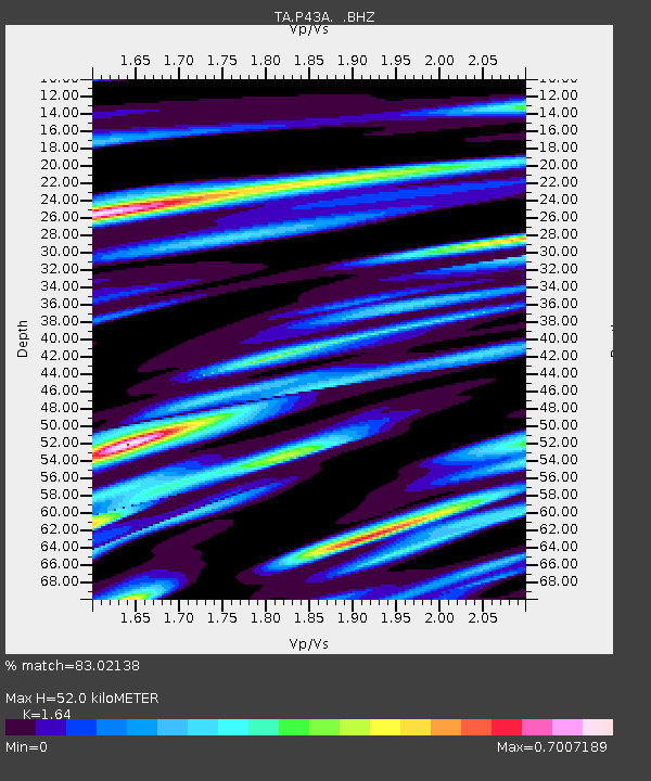
| Estimated Moho Depth: |
52.0 km |
| Estimated Crust Vp/Vs: |
1.64 |
| Assumed Crust Vp: |
6.444 km/s |
| Estimated Crust Vs: |
3.929 km/s |
| Estimated Crust Poisson's Ratio: |
0.20 |
|
| Radial Match: |
83.02138 % |
| Radial Bump: |
400 |
| Transverse Match: |
75.64589 % |
| Transverse Bump: |
400 |
| SOD ConfigId: |
512894 |
| Insert Time: |
2013-09-14 15:28:49.450 +0000 |
| GWidth: |
2.5 |
| Max Bumps: |
400 |
| Tol: |
0.001 |
|

Signal To Noise
| Channel | StoN | STA | LTA |
| TA:P43A: :BHZ:20130521T23:11:40.200007Z | 4.5548854 | 3.4313769E-7 | 7.533399E-8 |
| TA:P43A: :BHN:20130521T23:11:40.200007Z | 1.5660298 | 2.0225207E-7 | 1.2914957E-7 |
| TA:P43A: :BHE:20130521T23:11:40.200007Z | 1.2580838 | 1.0344168E-7 | 8.222161E-8 |
| Arrivals |
| Ps | 5.5 SECOND |
| PpPs | 20 SECOND |
| PsPs/PpSs | 26 SECOND |


