You are here: Home > Network List > TA - USArray Transportable Network (new EarthScope stations) Stations List
> Station P48A Milroy, IN, USA > Earthquake Result Viewer
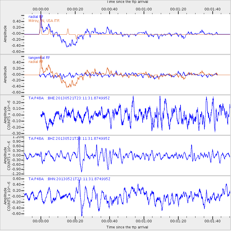
P48A Milroy, IN, USA - Earthquake Result Viewer
*The percent match for this event was below the threshold and hence no stack was calculated.
| Earthquake location: |
Central Peru |
| Earthquake latitude/longitude: |
-13.8/-72.3 |
| Earthquake time(UTC): |
2013/05/21 (141) 23:02:45 GMT |
| Earthquake Depth: |
92 km |
| Earthquake Magnitude: |
5.8 MW, 5.7 MB, 5.8 MW |
| Earthquake Catalog/Contributor: |
NEIC PDE/NEIC PDE-W |
|
| Network: |
TA USArray Transportable Network (new EarthScope stations) |
| Station: |
P48A Milroy, IN, USA |
| Lat/Lon: |
39.46 N/85.43 W |
| Elevation: |
300 m |
|
| Distance: |
54.4 deg |
| Az: |
347.474 deg |
| Baz: |
164.206 deg |
| Ray Param: |
$rayparam |
*The percent match for this event was below the threshold and hence was not used in the summary stack. |
|
| Radial Match: |
62.748672 % |
| Radial Bump: |
400 |
| Transverse Match: |
60.50021 % |
| Transverse Bump: |
400 |
| SOD ConfigId: |
512894 |
| Insert Time: |
2013-09-14 15:28:58.739 +0000 |
| GWidth: |
2.5 |
| Max Bumps: |
400 |
| Tol: |
0.001 |
|
Signal To Noise
| Channel | StoN | STA | LTA |
| TA:P48A: :BHZ:20130521T23:11:31.874995Z | 2.3538857 | 2.4046935E-7 | 1.0215847E-7 |
| TA:P48A: :BHN:20130521T23:11:31.874995Z | 1.4348133 | 1.7561062E-7 | 1.2239268E-7 |
| TA:P48A: :BHE:20130521T23:11:31.874995Z | 0.67304134 | 4.9876896E-8 | 7.410674E-8 |
| Arrivals |
| Ps | |
| PpPs | |
| PsPs/PpSs | |


