You are here: Home > Network List > TA - USArray Transportable Network (new EarthScope stations) Stations List
> Station Q45A Warren Harvey, Newton, IL, USA > Earthquake Result Viewer
Q45A Warren Harvey, Newton, IL, USA - Earthquake Result Viewer

| Earthquake location: |
Central Peru |
| Earthquake latitude/longitude: |
-13.8/-72.3 |
| Earthquake time(UTC): |
2013/05/21 (141) 23:02:45 GMT |
| Earthquake Depth: |
92 km |
| Earthquake Magnitude: |
5.8 MW, 5.7 MB, 5.8 MW |
| Earthquake Catalog/Contributor: |
NEIC PDE/NEIC PDE-W |
|
| Network: |
TA USArray Transportable Network (new EarthScope stations) |
| Station: |
Q45A Warren Harvey, Newton, IL, USA |
| Lat/Lon: |
38.89 N/88.16 W |
| Elevation: |
162 m |
|
| Distance: |
54.5 deg |
| Az: |
344.777 deg |
| Baz: |
160.918 deg |
| Ray Param: |
0.06515345 |
| Estimated Moho Depth: |
27.0 km |
| Estimated Crust Vp/Vs: |
1.60 |
| Assumed Crust Vp: |
6.444 km/s |
| Estimated Crust Vs: |
4.027 km/s |
| Estimated Crust Poisson's Ratio: |
0.18 |
|
| Radial Match: |
91.754654 % |
| Radial Bump: |
380 |
| Transverse Match: |
70.13112 % |
| Transverse Bump: |
400 |
| SOD ConfigId: |
512894 |
| Insert Time: |
2013-09-14 15:29:37.505 +0000 |
| GWidth: |
2.5 |
| Max Bumps: |
400 |
| Tol: |
0.001 |
|
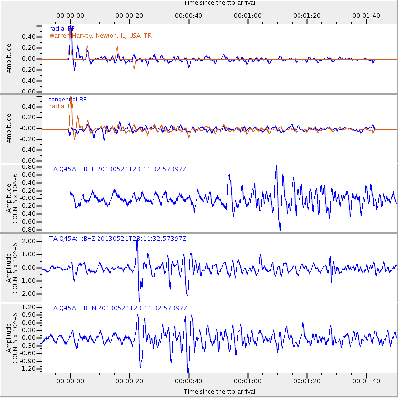
Signal To Noise
| Channel | StoN | STA | LTA |
| TA:Q45A: :BHZ:20130521T23:11:32.57397Z | 3.5962212 | 3.9723176E-7 | 1.10458096E-7 |
| TA:Q45A: :BHN:20130521T23:11:32.57397Z | 2.1201053 | 1.6746762E-7 | 7.899023E-8 |
| TA:Q45A: :BHE:20130521T23:11:32.57397Z | 0.93299186 | 1.0138716E-7 | 1.0866885E-7 |
| Arrivals |
| Ps | 2.7 SECOND |
| PpPs | 10 SECOND |
| PsPs/PpSs | 13 SECOND |


