You are here: Home > Network List > PS - Pacific21 Stations List
> Station TSK Tsukuba, Japan > Earthquake Result Viewer
TSK Tsukuba, Japan - Earthquake Result Viewer

| Earthquake location: |
Tonga Islands |
| Earthquake latitude/longitude: |
-22.0/-174.9 |
| Earthquake time(UTC): |
1993/01/04 (004) 20:41:11 GMT |
| Earthquake Depth: |
33 km |
| Earthquake Magnitude: |
5.6 MB, 6.3 MS |
| Earthquake Catalog/Contributor: |
WHDF/NEIC |
|
| Network: |
PS Pacific21 |
| Station: |
TSK Tsukuba, Japan |
| Lat/Lon: |
36.21 N/140.11 E |
| Elevation: |
350 m |
|
| Distance: |
71.8 deg |
| Az: |
322.995 deg |
| Baz: |
136.312 deg |
| Ray Param: |
0.054013826 |
| Estimated Moho Depth: |
51.5 km |
| Estimated Crust Vp/Vs: |
1.68 |
| Assumed Crust Vp: |
6.24 km/s |
| Estimated Crust Vs: |
3.714 km/s |
| Estimated Crust Poisson's Ratio: |
0.23 |
|
| Radial Match: |
83.91718 % |
| Radial Bump: |
400 |
| Transverse Match: |
64.94528 % |
| Transverse Bump: |
400 |
| SOD ConfigId: |
16938 |
| Insert Time: |
2010-02-27 03:50:44.818 +0000 |
| GWidth: |
2.5 |
| Max Bumps: |
400 |
| Tol: |
0.001 |
|
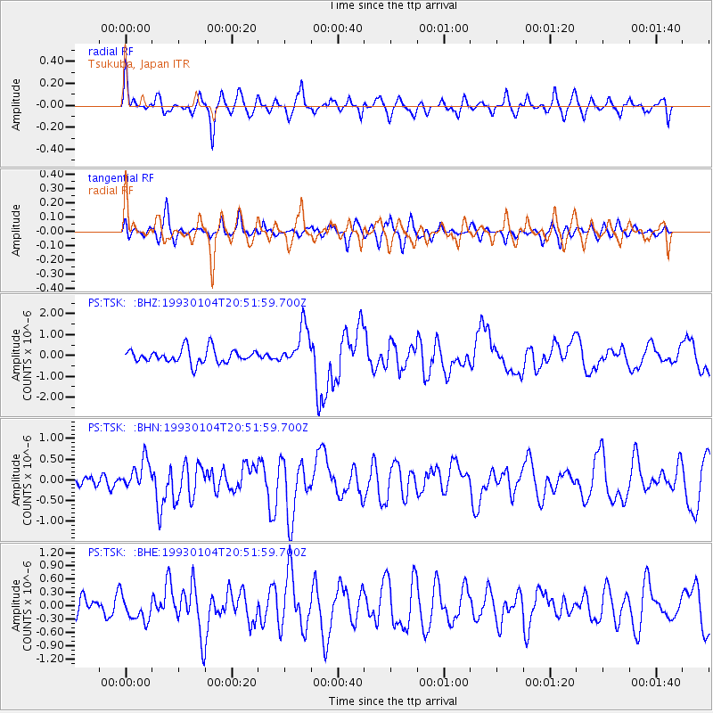
Signal To Noise
| Channel | StoN | STA | LTA |
| PS:TSK: :BHN:19930104T20:51:59.700Z | 2.0900297 | 3.559228E-7 | 1.7029556E-7 |
| PS:TSK: :BHE:19930104T20:51:59.700Z | 1.0572466 | 2.7029824E-7 | 2.5566243E-7 |
| PS:TSK: :BHZ:19930104T20:51:59.700Z | 2.8091822 | 9.53065E-7 | 3.3926779E-7 |
| Arrivals |
| Ps | 5.8 SECOND |
| PpPs | 21 SECOND |
| PsPs/PpSs | 27 SECOND |


