You are here: Home > Network List > PS - Pacific21 Stations List
> Station TSK Tsukuba, Japan > Earthquake Result Viewer
TSK Tsukuba, Japan - Earthquake Result Viewer
| Earthquake location: |
Banda Sea |
| Earthquake latitude/longitude: |
-7.2/128.6 |
| Earthquake time(UTC): |
1993/01/20 (020) 17:31:15 GMT |
| Earthquake Depth: |
33 km |
| Earthquake Magnitude: |
6.0 MB, 6.3 MS |
| Earthquake Catalog/Contributor: |
WHDF/NEIC |
|
| Network: |
PS Pacific21 |
| Station: |
TSK Tsukuba, Japan |
| Lat/Lon: |
36.21 N/140.11 E |
| Elevation: |
350 m |
|
| Distance: |
44.6 deg |
| Az: |
13.304 deg |
| Baz: |
196.398 deg |
| Ray Param: |
0.071783535 |
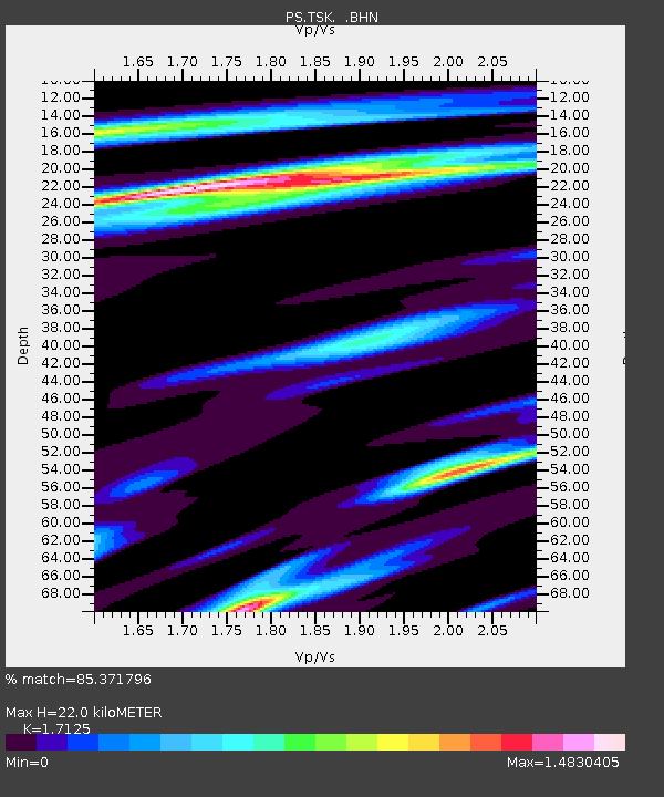
| Estimated Moho Depth: |
22.0 km |
| Estimated Crust Vp/Vs: |
1.71 |
| Assumed Crust Vp: |
6.24 km/s |
| Estimated Crust Vs: |
3.644 km/s |
| Estimated Crust Poisson's Ratio: |
0.24 |
|
| Radial Match: |
85.371796 % |
| Radial Bump: |
385 |
| Transverse Match: |
83.50557 % |
| Transverse Bump: |
366 |
| SOD ConfigId: |
16938 |
| Insert Time: |
2010-02-27 03:50:48.086 +0000 |
| GWidth: |
2.5 |
| Max Bumps: |
400 |
| Tol: |
0.001 |
|

Signal To Noise
| Channel | StoN | STA | LTA |
| PS:TSK: :BHN:19930120T17:38:53.852008Z | 3.0771358 | 1.0442382E-6 | 3.3935393E-7 |
| PS:TSK: :BHE:19930120T17:38:53.852008Z | 1.1956081 | 6.3954604E-7 | 5.349128E-7 |
| PS:TSK: :BHZ:19930120T17:38:53.852008Z | 3.5232217 | 1.946578E-6 | 5.5249944E-7 |
| Arrivals |
| Ps | 2.7 SECOND |
| PpPs | 9.0 SECOND |
| PsPs/PpSs | 12 SECOND |


