You are here: Home > Network List > TA - USArray Transportable Network (new EarthScope stations) Stations List
> Station S47A Hartford, KY, USA > Earthquake Result Viewer
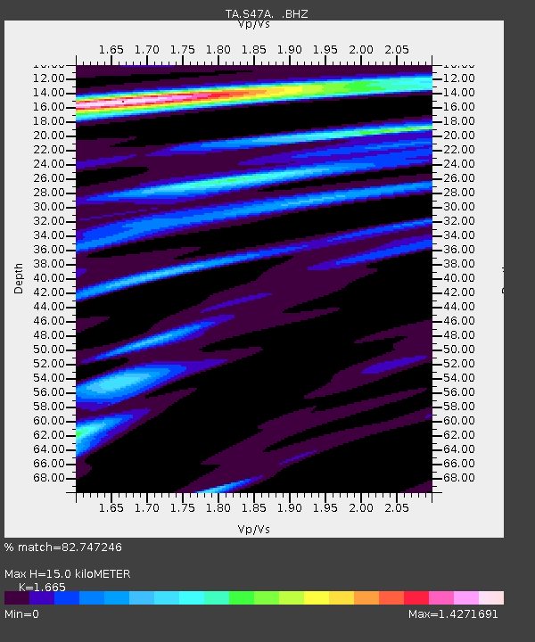
S47A Hartford, KY, USA - Earthquake Result Viewer
| Earthquake location: |
Central Peru |
| Earthquake latitude/longitude: |
-13.8/-72.3 |
| Earthquake time(UTC): |
2013/05/21 (141) 23:02:45 GMT |
| Earthquake Depth: |
92 km |
| Earthquake Magnitude: |
5.8 MW, 5.7 MB, 5.8 MW |
| Earthquake Catalog/Contributor: |
NEIC PDE/NEIC PDE-W |
|
| Network: |
TA USArray Transportable Network (new EarthScope stations) |
| Station: |
S47A Hartford, KY, USA |
| Lat/Lon: |
37.59 N/86.88 W |
| Elevation: |
181 m |
|
| Distance: |
52.9 deg |
| Az: |
345.451 deg |
| Baz: |
162.105 deg |
| Ray Param: |
0.06615588 |
| Estimated Moho Depth: |
15.0 km |
| Estimated Crust Vp/Vs: |
1.66 |
| Assumed Crust Vp: |
6.444 km/s |
| Estimated Crust Vs: |
3.87 km/s |
| Estimated Crust Poisson's Ratio: |
0.22 |
|
| Radial Match: |
82.747246 % |
| Radial Bump: |
400 |
| Transverse Match: |
76.57226 % |
| Transverse Bump: |
400 |
| SOD ConfigId: |
512894 |
| Insert Time: |
2013-09-14 15:31:22.424 +0000 |
| GWidth: |
2.5 |
| Max Bumps: |
400 |
| Tol: |
0.001 |
|

Signal To Noise
| Channel | StoN | STA | LTA |
| TA:S47A: :BHZ:20130521T23:11:21.299983Z | 6.2661963 | 4.031251E-7 | 6.43333E-8 |
| TA:S47A: :BHN:20130521T23:11:21.299983Z | 2.2775242 | 1.7866805E-7 | 7.844836E-8 |
| TA:S47A: :BHE:20130521T23:11:21.299983Z | 1.1055663 | 6.517508E-8 | 5.8951766E-8 |
| Arrivals |
| Ps | 1.6 SECOND |
| PpPs | 5.9 SECOND |
| PsPs/PpSs | 7.5 SECOND |


