You are here: Home > Network List > TA - USArray Transportable Network (new EarthScope stations) Stations List
> Station T45A Paducah, KY, USA > Earthquake Result Viewer
T45A Paducah, KY, USA - Earthquake Result Viewer
| Earthquake location: |
Central Peru |
| Earthquake latitude/longitude: |
-13.8/-72.3 |
| Earthquake time(UTC): |
2013/05/21 (141) 23:02:45 GMT |
| Earthquake Depth: |
92 km |
| Earthquake Magnitude: |
5.8 MW, 5.7 MB, 5.8 MW |
| Earthquake Catalog/Contributor: |
NEIC PDE/NEIC PDE-W |
|
| Network: |
TA USArray Transportable Network (new EarthScope stations) |
| Station: |
T45A Paducah, KY, USA |
| Lat/Lon: |
37.02 N/88.64 W |
| Elevation: |
119 m |
|
| Distance: |
52.8 deg |
| Az: |
343.546 deg |
| Baz: |
159.889 deg |
| Ray Param: |
0.06621183 |
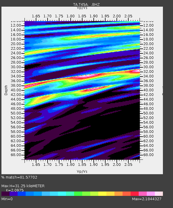
| Estimated Moho Depth: |
31.25 km |
| Estimated Crust Vp/Vs: |
2.10 |
| Assumed Crust Vp: |
6.444 km/s |
| Estimated Crust Vs: |
3.072 km/s |
| Estimated Crust Poisson's Ratio: |
0.35 |
|
| Radial Match: |
81.57702 % |
| Radial Bump: |
400 |
| Transverse Match: |
76.95449 % |
| Transverse Bump: |
400 |
| SOD ConfigId: |
512894 |
| Insert Time: |
2013-09-14 15:32:03.350 +0000 |
| GWidth: |
2.5 |
| Max Bumps: |
400 |
| Tol: |
0.001 |
|

Signal To Noise
| Channel | StoN | STA | LTA |
| TA:T45A: :BHZ:20130521T23:11:20.674983Z | 2.1034563 | 4.7013623E-7 | 2.2350655E-7 |
| TA:T45A: :BHN:20130521T23:11:20.674983Z | 2.3757734 | 5.1867227E-7 | 2.1831723E-7 |
| TA:T45A: :BHE:20130521T23:11:20.674983Z | 1.6656047 | 4.288445E-7 | 2.5747073E-7 |
| Arrivals |
| Ps | 5.6 SECOND |
| PpPs | 14 SECOND |
| PsPs/PpSs | 20 SECOND |


