You are here: Home > Network List > TA - USArray Transportable Network (new EarthScope stations) Stations List
> Station T48A Bowling Green, KY, USA > Earthquake Result Viewer
T48A Bowling Green, KY, USA - Earthquake Result Viewer
| Earthquake location: |
Central Peru |
| Earthquake latitude/longitude: |
-13.8/-72.3 |
| Earthquake time(UTC): |
2013/05/21 (141) 23:02:45 GMT |
| Earthquake Depth: |
92 km |
| Earthquake Magnitude: |
5.8 MW, 5.7 MB, 5.8 MW |
| Earthquake Catalog/Contributor: |
NEIC PDE/NEIC PDE-W |
|
| Network: |
TA USArray Transportable Network (new EarthScope stations) |
| Station: |
T48A Bowling Green, KY, USA |
| Lat/Lon: |
37.11 N/86.39 W |
| Elevation: |
218 m |
|
| Distance: |
52.3 deg |
| Az: |
345.728 deg |
| Baz: |
162.566 deg |
| Ray Param: |
0.06654088 |
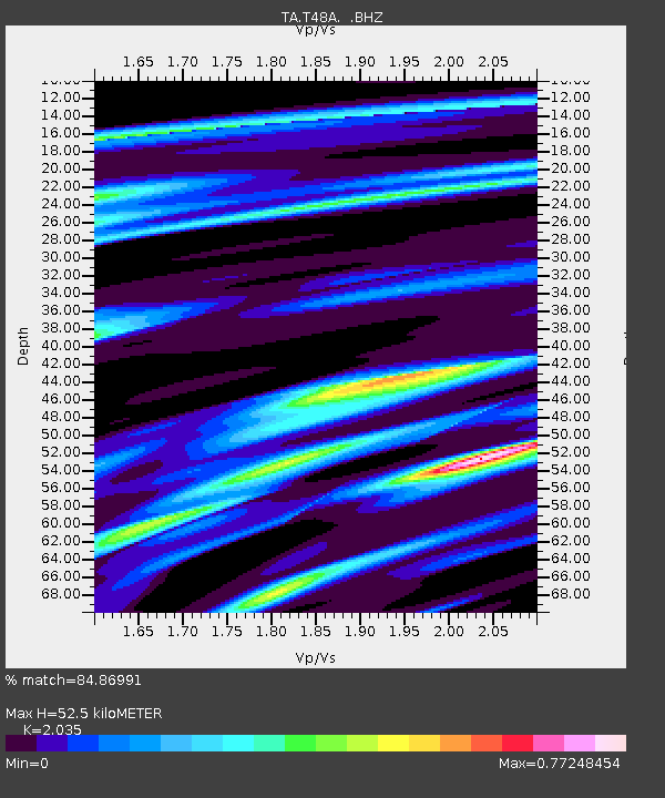
| Estimated Moho Depth: |
52.5 km |
| Estimated Crust Vp/Vs: |
2.04 |
| Assumed Crust Vp: |
6.444 km/s |
| Estimated Crust Vs: |
3.167 km/s |
| Estimated Crust Poisson's Ratio: |
0.34 |
|
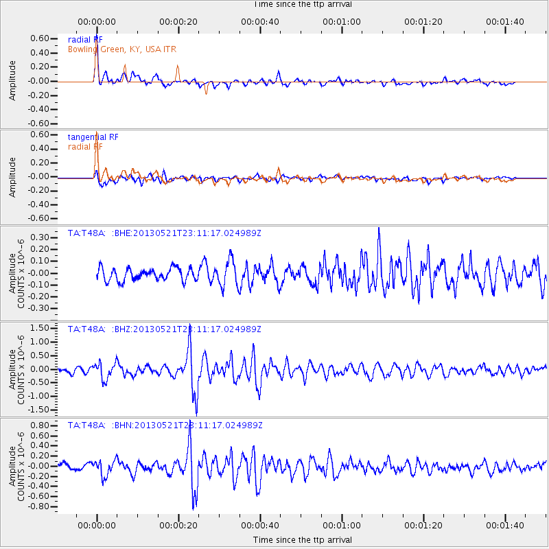
| Radial Match: |
84.86991 % |
| Radial Bump: |
400 |
| Transverse Match: |
69.10294 % |
| Transverse Bump: |
400 |
| SOD ConfigId: |
512894 |
| Insert Time: |
2013-09-14 15:32:09.611 +0000 |
| GWidth: |
2.5 |
| Max Bumps: |
400 |
| Tol: |
0.001 |
|
Signal To Noise
| Channel | StoN | STA | LTA |
| TA:T48A: :BHZ:20130521T23:11:17.024989Z | 4.035597 | 3.0699604E-7 | 7.6072034E-8 |
| TA:T48A: :BHN:20130521T23:11:17.024989Z | 1.883525 | 1.5569529E-7 | 8.266166E-8 |
| TA:T48A: :BHE:20130521T23:11:17.024989Z | 2.1911256 | 1.1282185E-7 | 5.1490364E-8 |
| Arrivals |
| Ps | 8.8 SECOND |
| PpPs | 24 SECOND |
| PsPs/PpSs | 32 SECOND |


