You are here: Home > Network List > TA - USArray Transportable Network (new EarthScope stations) Stations List
> Station T47A Sharon Grove, KY, USA > Earthquake Result Viewer
T47A Sharon Grove, KY, USA - Earthquake Result Viewer
| Earthquake location: |
Central Peru |
| Earthquake latitude/longitude: |
-13.8/-72.3 |
| Earthquake time(UTC): |
2013/05/21 (141) 23:02:45 GMT |
| Earthquake Depth: |
92 km |
| Earthquake Magnitude: |
5.8 MW, 5.7 MB, 5.8 MW |
| Earthquake Catalog/Contributor: |
NEIC PDE/NEIC PDE-W |
|
| Network: |
TA USArray Transportable Network (new EarthScope stations) |
| Station: |
T47A Sharon Grove, KY, USA |
| Lat/Lon: |
36.99 N/87.11 W |
| Elevation: |
217 m |
|
| Distance: |
52.4 deg |
| Az: |
344.997 deg |
| Baz: |
161.693 deg |
| Ray Param: |
0.06650187 |
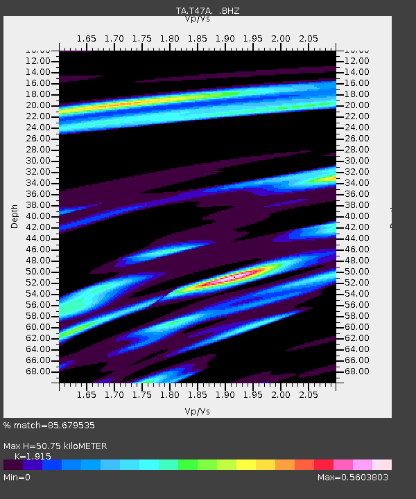
| Estimated Moho Depth: |
50.75 km |
| Estimated Crust Vp/Vs: |
1.91 |
| Assumed Crust Vp: |
6.444 km/s |
| Estimated Crust Vs: |
3.365 km/s |
| Estimated Crust Poisson's Ratio: |
0.31 |
|
| Radial Match: |
85.679535 % |
| Radial Bump: |
400 |
| Transverse Match: |
59.380177 % |
| Transverse Bump: |
400 |
| SOD ConfigId: |
512894 |
| Insert Time: |
2013-09-14 15:32:10.090 +0000 |
| GWidth: |
2.5 |
| Max Bumps: |
400 |
| Tol: |
0.001 |
|
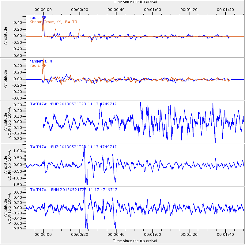
Signal To Noise
| Channel | StoN | STA | LTA |
| TA:T47A: :BHZ:20130521T23:11:17.474971Z | 3.9567142 | 2.6990008E-7 | 6.821319E-8 |
| TA:T47A: :BHN:20130521T23:11:17.474971Z | 2.7041001 | 1.3875044E-7 | 5.1311133E-8 |
| TA:T47A: :BHE:20130521T23:11:17.474971Z | 1.8582593 | 1.347808E-7 | 7.2530675E-8 |
| Arrivals |
| Ps | 7.6 SECOND |
| PpPs | 22 SECOND |
| PsPs/PpSs | 29 SECOND |


