You are here: Home > Network List > PS - Pacific21 Stations List
> Station TSK Tsukuba, Japan > Earthquake Result Viewer
TSK Tsukuba, Japan - Earthquake Result Viewer
| Earthquake location: |
North Of Halmahera, Indonesia |
| Earthquake latitude/longitude: |
4.0/128.2 |
| Earthquake time(UTC): |
1993/04/19 (109) 21:01:54 GMT |
| Earthquake Depth: |
70 km |
| Earthquake Magnitude: |
6.1 MB, 6.7 MS, 6.8 UNKNOWN |
| Earthquake Catalog/Contributor: |
WHDF/NEIC |
|
| Network: |
PS Pacific21 |
| Station: |
TSK Tsukuba, Japan |
| Lat/Lon: |
36.21 N/140.11 E |
| Elevation: |
350 m |
|
| Distance: |
33.9 deg |
| Az: |
17.439 deg |
| Baz: |
201.695 deg |
| Ray Param: |
0.07783125 |
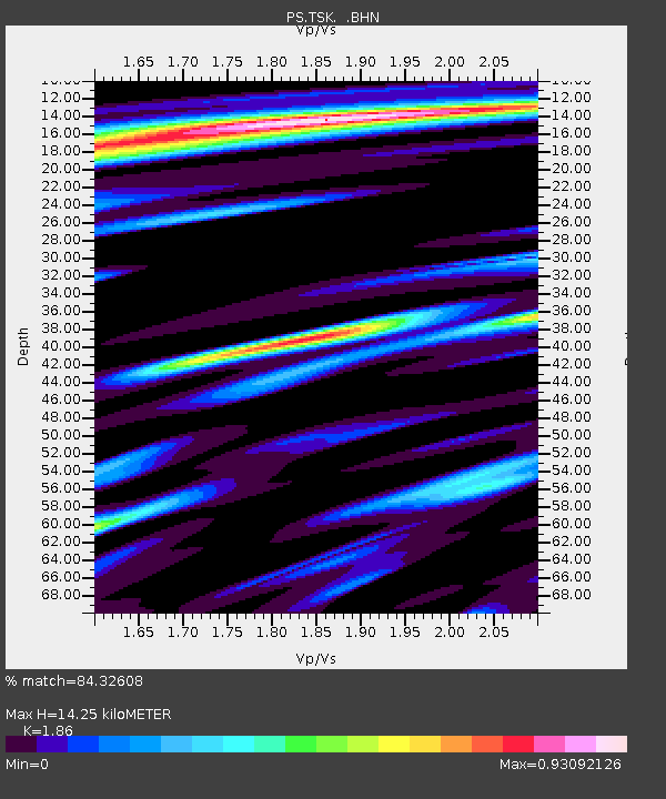
| Estimated Moho Depth: |
14.25 km |
| Estimated Crust Vp/Vs: |
1.86 |
| Assumed Crust Vp: |
6.24 km/s |
| Estimated Crust Vs: |
3.355 km/s |
| Estimated Crust Poisson's Ratio: |
0.30 |
|
| Radial Match: |
84.32608 % |
| Radial Bump: |
400 |
| Transverse Match: |
58.96015 % |
| Transverse Bump: |
400 |
| SOD ConfigId: |
16938 |
| Insert Time: |
2010-02-27 03:50:54.909 +0000 |
| GWidth: |
2.5 |
| Max Bumps: |
400 |
| Tol: |
0.001 |
|

Signal To Noise
| Channel | StoN | STA | LTA |
| PS:TSK: :BHN:19930419T21:08:00.148987Z | 1.9679668 | 4.4400133E-7 | 2.2561424E-7 |
| PS:TSK: :BHE:19930419T21:08:00.148987Z | 1.4942814 | 3.3668422E-7 | 2.2531513E-7 |
| PS:TSK: :BHZ:19930419T21:08:00.148987Z | 2.774428 | 5.630059E-7 | 2.0292686E-7 |
| Arrivals |
| Ps | 2.1 SECOND |
| PpPs | 6.1 SECOND |
| PsPs/PpSs | 8.2 SECOND |


