You are here: Home > Network List > TA - USArray Transportable Network (new EarthScope stations) Stations List
> Station T56A Rocky Mt, VA, USA > Earthquake Result Viewer
T56A Rocky Mt, VA, USA - Earthquake Result Viewer
| Earthquake location: |
Central Peru |
| Earthquake latitude/longitude: |
-13.8/-72.3 |
| Earthquake time(UTC): |
2013/05/21 (141) 23:02:45 GMT |
| Earthquake Depth: |
92 km |
| Earthquake Magnitude: |
5.8 MW, 5.7 MB, 5.8 MW |
| Earthquake Catalog/Contributor: |
NEIC PDE/NEIC PDE-W |
|
| Network: |
TA USArray Transportable Network (new EarthScope stations) |
| Station: |
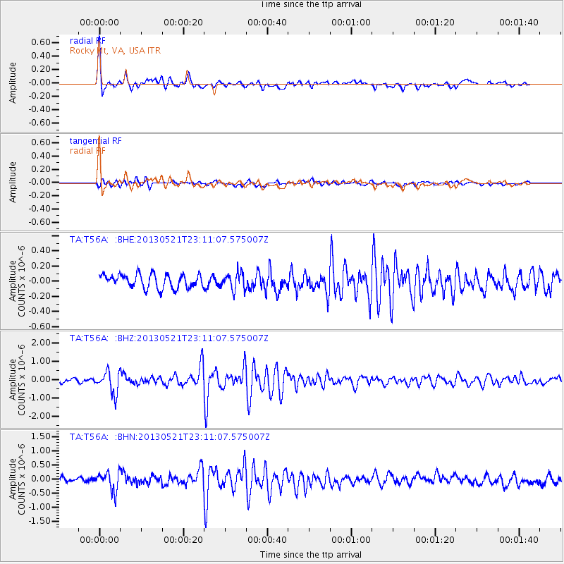
T56A Rocky Mt, VA, USA |
| Lat/Lon: |
37.03 N/80.03 W |
| Elevation: |
387 m |
|
| Distance: |
51.1 deg |
| Az: |
352.007 deg |
| Baz: |
170.281 deg |
| Ray Param: |
0.06736676 |
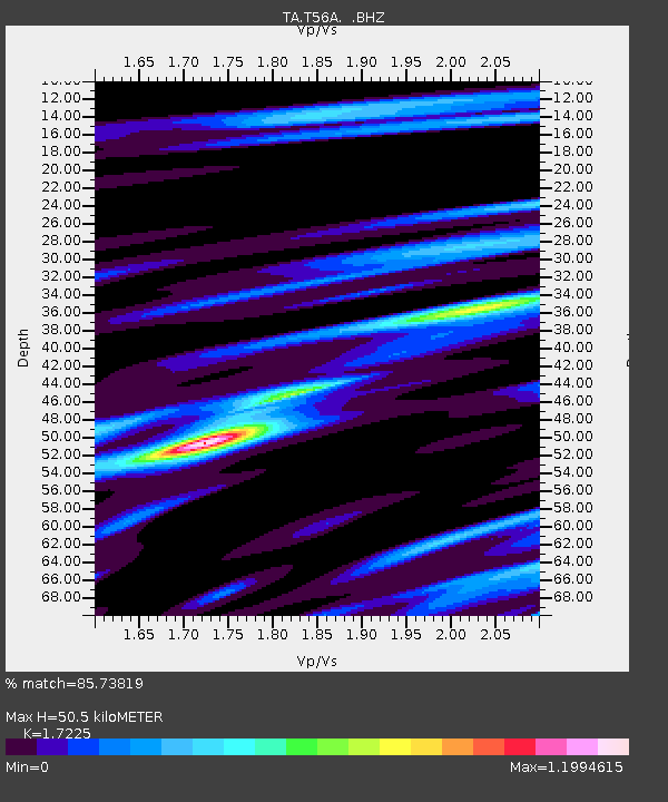
| Estimated Moho Depth: |
50.5 km |
| Estimated Crust Vp/Vs: |
1.72 |
| Assumed Crust Vp: |
6.159 km/s |
| Estimated Crust Vs: |
3.575 km/s |
| Estimated Crust Poisson's Ratio: |
0.25 |
|
| Radial Match: |
85.73819 % |
| Radial Bump: |
400 |
| Transverse Match: |
69.997215 % |
| Transverse Bump: |
400 |
| SOD ConfigId: |
512894 |
| Insert Time: |
2013-09-14 15:32:34.353 +0000 |
| GWidth: |
2.5 |
| Max Bumps: |
400 |
| Tol: |
0.001 |
|
Signal To Noise
| Channel | StoN | STA | LTA |
| TA:T56A: :BHZ:20130521T23:11:07.575007Z | 5.187358 | 6.0893376E-7 | 1.1738803E-7 |
| TA:T56A: :BHN:20130521T23:11:07.575007Z | 4.1216855 | 3.465445E-7 | 8.407836E-8 |
| TA:T56A: :BHE:20130521T23:11:07.575007Z | 1.257542 | 1.1182015E-7 | 8.891961E-8 |
| Arrivals |
| Ps | 6.2 SECOND |
| PpPs | 21 SECOND |
| PsPs/PpSs | 27 SECOND |


