You are here: Home > Network List > TA - USArray Transportable Network (new EarthScope stations) Stations List
> Station T59A Double 'B' Farms, VA, USA > Earthquake Result Viewer
T59A Double 'B' Farms, VA, USA - Earthquake Result Viewer
| Earthquake location: |
Central Peru |
| Earthquake latitude/longitude: |
-13.8/-72.3 |
| Earthquake time(UTC): |
2013/05/21 (141) 23:02:45 GMT |
| Earthquake Depth: |
92 km |
| Earthquake Magnitude: |
5.8 MW, 5.7 MB, 5.8 MW |
| Earthquake Catalog/Contributor: |
NEIC PDE/NEIC PDE-W |
|
| Network: |
TA USArray Transportable Network (new EarthScope stations) |
| Station: |
T59A Double 'B' Farms, VA, USA |
| Lat/Lon: |
36.97 N/77.55 W |
| Elevation: |
63 m |
|
| Distance: |
50.7 deg |
| Az: |
354.526 deg |
| Baz: |
173.354 deg |
| Ray Param: |
0.067577966 |
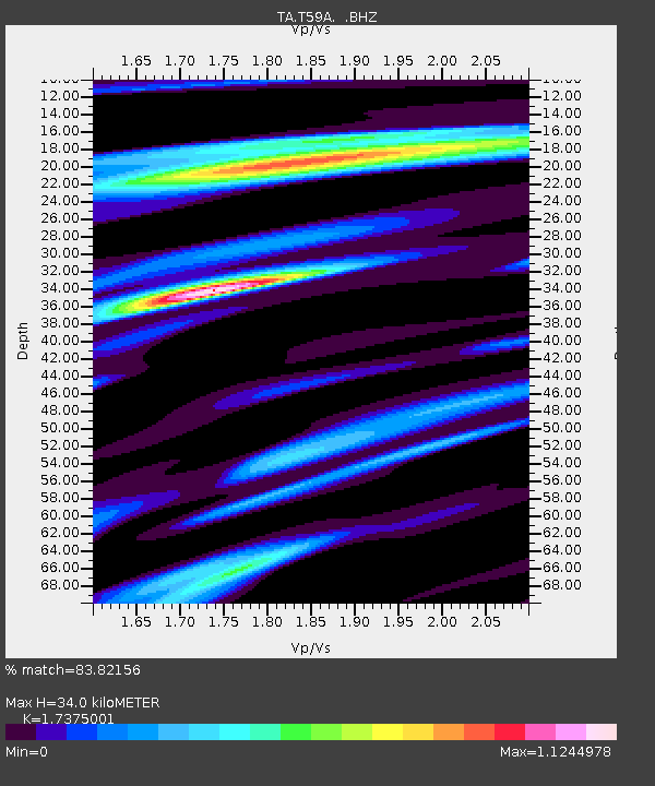
| Estimated Moho Depth: |
34.0 km |
| Estimated Crust Vp/Vs: |
1.74 |
| Assumed Crust Vp: |
6.565 km/s |
| Estimated Crust Vs: |
3.778 km/s |
| Estimated Crust Poisson's Ratio: |
0.25 |
|
| Radial Match: |
83.82156 % |
| Radial Bump: |
400 |
| Transverse Match: |
60.42493 % |
| Transverse Bump: |
400 |
| SOD ConfigId: |
512894 |
| Insert Time: |
2013-09-14 15:32:44.598 +0000 |
| GWidth: |
2.5 |
| Max Bumps: |
400 |
| Tol: |
0.001 |
|

Signal To Noise
| Channel | StoN | STA | LTA |
| TA:T59A: :BHZ:20130521T23:11:05.050013Z | 7.6612844 | 6.212455E-7 | 8.108894E-8 |
| TA:T59A: :BHN:20130521T23:11:05.050013Z | 5.069864 | 3.5023402E-7 | 6.908154E-8 |
| TA:T59A: :BHE:20130521T23:11:05.050013Z | 1.3388335 | 8.1418335E-8 | 6.0812894E-8 |
| Arrivals |
| Ps | 4.1 SECOND |
| PpPs | 13 SECOND |
| PsPs/PpSs | 17 SECOND |


