You are here: Home > Network List > PS - Pacific21 Stations List
> Station TSK Tsukuba, Japan > Earthquake Result Viewer
TSK Tsukuba, Japan - Earthquake Result Viewer
| Earthquake location: |
California-Nevada Border Region |
| Earthquake latitude/longitude: |
37.2/-117.8 |
| Earthquake time(UTC): |
1993/05/17 (137) 23:20:49 GMT |
| Earthquake Depth: |
7.0 km |
| Earthquake Magnitude: |
6.0 MB, 5.8 MS, 6.2 UNKNOWN, 6.2 ML |
| Earthquake Catalog/Contributor: |
WHDF/NEIC |
|
| Network: |
PS Pacific21 |
| Station: |
TSK Tsukuba, Japan |
| Lat/Lon: |
36.21 N/140.11 E |
| Elevation: |
350 m |
|
| Distance: |
77.4 deg |
| Az: |
305.879 deg |
| Baz: |
53.158 deg |
| Ray Param: |
0.05035925 |
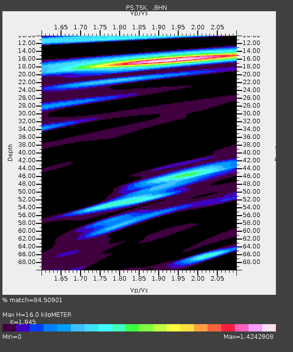
| Estimated Moho Depth: |
16.0 km |
| Estimated Crust Vp/Vs: |
1.95 |
| Assumed Crust Vp: |
6.24 km/s |
| Estimated Crust Vs: |
3.208 km/s |
| Estimated Crust Poisson's Ratio: |
0.32 |
|
| Radial Match: |
84.50901 % |
| Radial Bump: |
400 |
| Transverse Match: |
76.78973 % |
| Transverse Bump: |
400 |
| SOD ConfigId: |
16938 |
| Insert Time: |
2010-02-27 03:51:02.465 +0000 |
| GWidth: |
2.5 |
| Max Bumps: |
400 |
| Tol: |
0.001 |
|

Signal To Noise
| Channel | StoN | STA | LTA |
| PS:TSK: :BHN:19930517T23:32:13.403003Z | 1.336546 | 1.3894555E-7 | 1.0395868E-7 |
| PS:TSK: :BHE:19930517T23:32:13.403003Z | 2.1912491 | 3.094593E-7 | 1.4122507E-7 |
| PS:TSK: :BHZ:19930517T23:32:13.403003Z | 4.842132 | 7.489634E-7 | 1.5467637E-7 |
| Arrivals |
| Ps | 2.5 SECOND |
| PpPs | 7.4 SECOND |
| PsPs/PpSs | 9.8 SECOND |


