You are here: Home > Network List > TA - USArray Transportable Network (new EarthScope stations) Stations List
> Station Y53A Monroe, GA, USA > Earthquake Result Viewer
Y53A Monroe, GA, USA - Earthquake Result Viewer
| Earthquake location: |
Central Peru |
| Earthquake latitude/longitude: |
-13.8/-72.3 |
| Earthquake time(UTC): |
2013/05/21 (141) 23:02:45 GMT |
| Earthquake Depth: |
92 km |
| Earthquake Magnitude: |
5.8 MW, 5.7 MB, 5.8 MW |
| Earthquake Catalog/Contributor: |
NEIC PDE/NEIC PDE-W |
|
| Network: |
TA USArray Transportable Network (new EarthScope stations) |
| Station: |
Y53A Monroe, GA, USA |
| Lat/Lon: |
33.86 N/83.58 W |
| Elevation: |
234 m |
|
| Distance: |
48.6 deg |
| Az: |
347.42 deg |
| Baz: |
165.268 deg |
| Ray Param: |
0.06895503 |
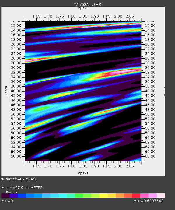
| Estimated Moho Depth: |
27.0 km |
| Estimated Crust Vp/Vs: |
1.60 |
| Assumed Crust Vp: |
6.565 km/s |
| Estimated Crust Vs: |
4.103 km/s |
| Estimated Crust Poisson's Ratio: |
0.18 |
|
| Radial Match: |
87.57498 % |
| Radial Bump: |
355 |
| Transverse Match: |
63.412357 % |
| Transverse Bump: |
400 |
| SOD ConfigId: |
512894 |
| Insert Time: |
2013-09-14 15:36:59.592 +0000 |
| GWidth: |
2.5 |
| Max Bumps: |
400 |
| Tol: |
0.001 |
|
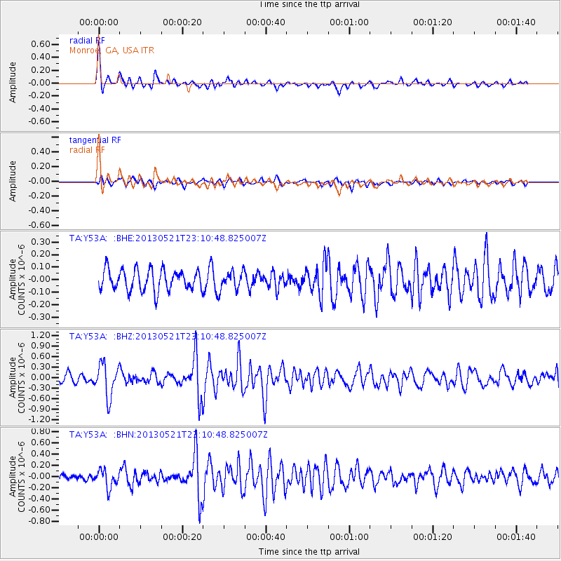
Signal To Noise
| Channel | StoN | STA | LTA |
| TA:Y53A: :BHZ:20130521T23:10:48.825007Z | 3.8496275 | 4.777185E-7 | 1.2409474E-7 |
| TA:Y53A: :BHN:20130521T23:10:48.825007Z | 2.7679586 | 1.6410304E-7 | 5.928667E-8 |
| TA:Y53A: :BHE:20130521T23:10:48.825007Z | 0.81229645 | 6.6944494E-8 | 8.241387E-8 |
| Arrivals |
| Ps | 2.6 SECOND |
| PpPs | 10.0 SECOND |
| PsPs/PpSs | 13 SECOND |


