You are here: Home > Network List > PS - Pacific21 Stations List
> Station TSK Tsukuba, Japan > Earthquake Result Viewer
TSK Tsukuba, Japan - Earthquake Result Viewer

| Earthquake location: |
South Of Fiji Islands |
| Earthquake latitude/longitude: |
-23.9/179.8 |
| Earthquake time(UTC): |
1993/08/07 (219) 17:53:27 GMT |
| Earthquake Depth: |
555 km |
| Earthquake Magnitude: |
6.0 MB, 5.9 UNKNOWN, 6.9 MW |
| Earthquake Catalog/Contributor: |
WHDF/NEIC |
|
| Network: |
PS Pacific21 |
| Station: |
TSK Tsukuba, Japan |
| Lat/Lon: |
36.21 N/140.11 E |
| Elevation: |
350 m |
|
| Distance: |
70.6 deg |
| Az: |
326.776 deg |
| Baz: |
141.668 deg |
| Ray Param: |
0.053031527 |
| Estimated Moho Depth: |
50.75 km |
| Estimated Crust Vp/Vs: |
1.75 |
| Assumed Crust Vp: |
6.24 km/s |
| Estimated Crust Vs: |
3.556 km/s |
| Estimated Crust Poisson's Ratio: |
0.26 |
|
| Radial Match: |
86.835976 % |
| Radial Bump: |
400 |
| Transverse Match: |
66.218925 % |
| Transverse Bump: |
400 |
| SOD ConfigId: |
16938 |
| Insert Time: |
2010-02-27 03:51:15.365 +0000 |
| GWidth: |
2.5 |
| Max Bumps: |
400 |
| Tol: |
0.001 |
|
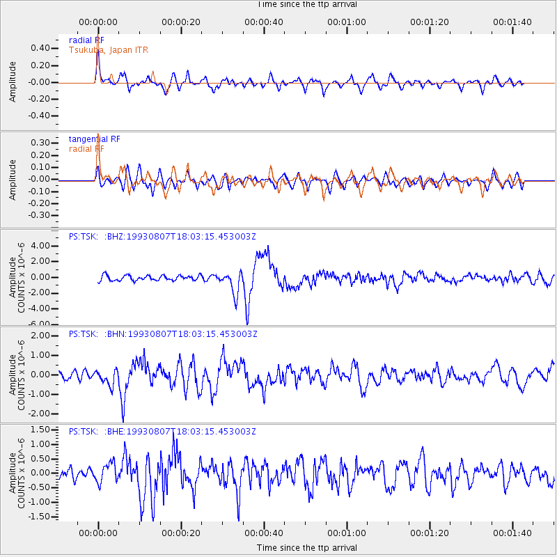
Signal To Noise
| Channel | StoN | STA | LTA |
| PS:TSK: :BHN:19930807T18:03:15.453003Z | 1.8668839 | 3.9082616E-7 | 2.0934681E-7 |
| PS:TSK: :BHE:19930807T18:03:15.453003Z | 1.4367092 | 3.3752224E-7 | 2.3492733E-7 |
| PS:TSK: :BHZ:19930807T18:03:15.453003Z | 4.4973707 | 1.456262E-6 | 3.2380296E-7 |
| Arrivals |
| Ps | 6.3 SECOND |
| PpPs | 22 SECOND |
| PsPs/PpSs | 28 SECOND |


