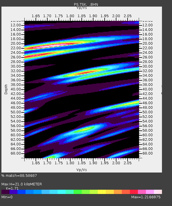
TSK Tsukuba, Japan - Earthquake Result Viewer

Earthquake location: New Guinea, Papua New Guinea
Earthquake latitude/longitude: -6.0/142.7
Earthquake time(UTC): 1993/08/20 (232) 05:06:52 GMT
Earthquake Depth: 7.0 km
Earthquake Magnitude: 6.0 MB, 6.2 MS, 6.4 UNKNOWN, 6.4 MW
Earthquake Catalog/Contributor: WHDF/NEIC
Network: PS Pacific21
Station: TSK Tsukuba, Japan
Lat/Lon: 36.21 N/140.11 E
Elevation: 350 m
Distance: 42.1 deg
Az: 356.925 deg
Baz: 176.218 deg
Ray Param: 0.07338263
Estimated Moho Depth: 21.0 km
Estimated Crust Vp/Vs: 1.71
Assumed Crust Vp: 6.24 km/s
Estimated Crust Vs: 3.649 km/s
Estimated Crust Poisson's Ratio: 0.24
Radial Match: 88.58687 %
Radial Bump: 400
Transverse Match: 81.251915 %
Transverse Bump: 400
SOD ConfigId: 16938
Insert Time: 2010-02-27 03:51:21.175 +0000
GWidth: 2.5
Max Bumps: 400
Tol: 0.001

Signal To Noise

ChannelStoNSTALTA
PS:TSK: :BHN:19930820T05:14:13.651001Z1.62625041.6189759E-79.955268E-8
PS:TSK: :BHE:19930820T05:14:13.651001Z1.9640191.4450413E-77.3575734E-8
PS:TSK: :BHZ:19930820T05:14:13.651001Z2.94238163.0604878E-71.04013964E-7
Arrivals
Ps2.6 SECOND
PpPs8.5 SECOND
PsPs/PpSs11 SECOND