You are here: Home > Network List > PS - Pacific21 Stations List
> Station TSK Tsukuba, Japan > Earthquake Result Viewer
TSK Tsukuba, Japan - Earthquake Result Viewer

| Earthquake location: |
Oregon |
| Earthquake latitude/longitude: |
42.4/-122.0 |
| Earthquake time(UTC): |
1993/09/21 (264) 05:45:34 GMT |
| Earthquake Depth: |
5.0 km |
| Earthquake Magnitude: |
5.5 MB, 5.7 MS, 5.9 UNKNOWN, 6.0 MD |
| Earthquake Catalog/Contributor: |
WHDF/NEIC |
|
| Network: |
PS Pacific21 |
| Station: |
TSK Tsukuba, Japan |
| Lat/Lon: |
36.21 N/140.11 E |
| Elevation: |
350 m |
|
| Distance: |
71.8 deg |
| Az: |
302.497 deg |
| Baz: |
50.63 deg |
| Ray Param: |
0.054111812 |
| Estimated Moho Depth: |
51.0 km |
| Estimated Crust Vp/Vs: |
1.90 |
| Assumed Crust Vp: |
6.24 km/s |
| Estimated Crust Vs: |
3.28 km/s |
| Estimated Crust Poisson's Ratio: |
0.31 |
|
| Radial Match: |
91.937645 % |
| Radial Bump: |
366 |
| Transverse Match: |
86.44397 % |
| Transverse Bump: |
400 |
| SOD ConfigId: |
16938 |
| Insert Time: |
2010-02-27 03:51:30.115 +0000 |
| GWidth: |
2.5 |
| Max Bumps: |
400 |
| Tol: |
0.001 |
|
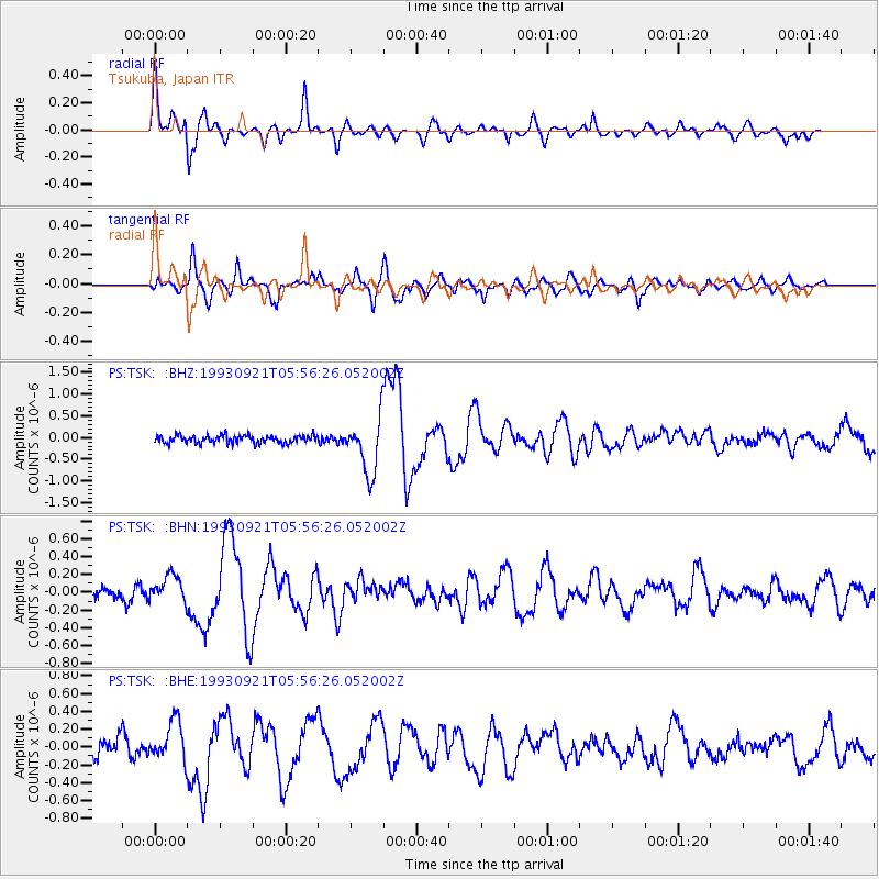
Signal To Noise
| Channel | StoN | STA | LTA |
| PS:TSK: :BHN:19930921T05:56:26.052002Z | 2.1919725 | 1.5391247E-7 | 7.021642E-8 |
| PS:TSK: :BHE:19930921T05:56:26.052002Z | 2.3937674 | 2.2023262E-7 | 9.2002516E-8 |
| PS:TSK: :BHZ:19930921T05:56:26.052002Z | 7.1599436 | 6.4117677E-7 | 8.955054E-8 |
| Arrivals |
| Ps | 7.6 SECOND |
| PpPs | 23 SECOND |
| PsPs/PpSs | 31 SECOND |


