You are here: Home > Network List > CB - China National Seismic Network Stations List
> Station DL2 Dalian,Liaoning Province > Earthquake Result Viewer
DL2 Dalian,Liaoning Province - Earthquake Result Viewer
| Earthquake location: |
Banda Sea |
| Earthquake latitude/longitude: |
-7.3/128.0 |
| Earthquake time(UTC): |
2014/08/06 (218) 11:45:22 GMT |
| Earthquake Depth: |
10 km |
| Earthquake Magnitude: |
6.1 MWP |
| Earthquake Catalog/Contributor: |
NEIC PDE/NEIC COMCAT |
|
| Network: |
CB China National Seismic Network |
| Station: |
DL2 Dalian,Liaoning Province |
| Lat/Lon: |
38.91 N/121.63 E |
| Elevation: |
65 m |
|
| Distance: |
46.3 deg |
| Az: |
353.075 deg |
| Baz: |
171.181 deg |
| Ray Param: |
0.07071249 |
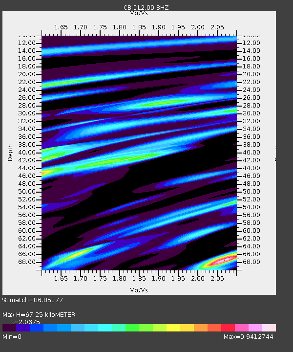
| Estimated Moho Depth: |
67.25 km |
| Estimated Crust Vp/Vs: |
2.07 |
| Assumed Crust Vp: |
6.134 km/s |
| Estimated Crust Vs: |
2.967 km/s |
| Estimated Crust Poisson's Ratio: |
0.35 |
|
| Radial Match: |
86.85177 % |
| Radial Bump: |
330 |
| Transverse Match: |
69.20076 % |
| Transverse Bump: |
400 |
| SOD ConfigId: |
3390531 |
| Insert Time: |
2019-04-13 05:48:01.727 +0000 |
| GWidth: |
2.5 |
| Max Bumps: |
400 |
| Tol: |
0.001 |
|

Signal To Noise
| Channel | StoN | STA | LTA |
| CB:DL2:00:BHZ:20140806T11:53:17.729989Z | 4.8147416 | 8.7424456E-7 | 1.8157662E-7 |
| CB:DL2:00:BHN:20140806T11:53:17.729989Z | 2.9071097 | 6.10853E-7 | 2.1012382E-7 |
| CB:DL2:00:BHE:20140806T11:53:17.729989Z | 1.0672534 | 1.7567474E-7 | 1.6460454E-7 |
| Arrivals |
| Ps | 12 SECOND |
| PpPs | 32 SECOND |
| PsPs/PpSs | 44 SECOND |


