You are here: Home > Network List > KN - Kyrgyz Seismic Telemetry Network Stations List
> Station EKS2 KN.EKS2 > Earthquake Result Viewer
EKS2 KN.EKS2 - Earthquake Result Viewer

| Earthquake location: |
Banda Sea |
| Earthquake latitude/longitude: |
-7.3/128.0 |
| Earthquake time(UTC): |
2014/08/06 (218) 11:45:22 GMT |
| Earthquake Depth: |
10 km |
| Earthquake Magnitude: |
6.1 MWP |
| Earthquake Catalog/Contributor: |
NEIC PDE/NEIC COMCAT |
|
| Network: |
KN Kyrgyz Seismic Telemetry Network |
| Station: |
EKS2 KN.EKS2 |
| Lat/Lon: |
42.66 N/73.78 E |
| Elevation: |
1360 m |
|
| Distance: |
70.0 deg |
| Az: |
320.408 deg |
| Baz: |
121.003 deg |
| Ray Param: |
0.055290397 |
| Estimated Moho Depth: |
15.5 km |
| Estimated Crust Vp/Vs: |
1.61 |
| Assumed Crust Vp: |
6.316 km/s |
| Estimated Crust Vs: |
3.923 km/s |
| Estimated Crust Poisson's Ratio: |
0.19 |
|
| Radial Match: |
92.26301 % |
| Radial Bump: |
400 |
| Transverse Match: |
87.6978 % |
| Transverse Bump: |
400 |
| SOD ConfigId: |
3390531 |
| Insert Time: |
2019-04-13 05:48:38.420 +0000 |
| GWidth: |
2.5 |
| Max Bumps: |
400 |
| Tol: |
0.001 |
|
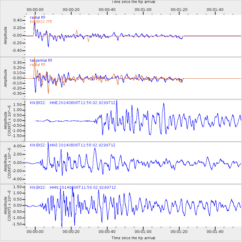
Signal To Noise
| Channel | StoN | STA | LTA |
| KN:EKS2: :HHZ:20140806T11:56:02.929971Z | 6.7373815 | 4.1943028E-7 | 6.22542E-8 |
| KN:EKS2: :HHN:20140806T11:56:02.929971Z | 1.5644075 | 8.635855E-8 | 5.5202083E-8 |
| KN:EKS2: :HHE:20140806T11:56:02.929971Z | 2.7525227 | 1.0385878E-7 | 3.7732214E-8 |
| Arrivals |
| Ps | 1.6 SECOND |
| PpPs | 6.2 SECOND |
| PsPs/PpSs | 7.7 SECOND |


