You are here: Home > Network List > PS - Pacific21 Stations List
> Station TSK Tsukuba, Japan > Earthquake Result Viewer
TSK Tsukuba, Japan - Earthquake Result Viewer

| Earthquake location: |
Solomon Islands |
| Earthquake latitude/longitude: |
-9.6/158.1 |
| Earthquake time(UTC): |
1993/11/26 (330) 23:20:05 GMT |
| Earthquake Depth: |
23 km |
| Earthquake Magnitude: |
5.8 MB, 6.2 MS, 6.1 UNKNOWN, 6.3 MW |
| Earthquake Catalog/Contributor: |
WHDF/NEIC |
|
| Network: |
PS Pacific21 |
| Station: |
TSK Tsukuba, Japan |
| Lat/Lon: |
36.21 N/140.11 E |
| Elevation: |
350 m |
|
| Distance: |
48.6 deg |
| Az: |
340.51 deg |
| Baz: |
155.992 deg |
| Ray Param: |
0.06920514 |
| Estimated Moho Depth: |
18.0 km |
| Estimated Crust Vp/Vs: |
2.09 |
| Assumed Crust Vp: |
6.24 km/s |
| Estimated Crust Vs: |
2.986 km/s |
| Estimated Crust Poisson's Ratio: |
0.35 |
|
| Radial Match: |
85.86911 % |
| Radial Bump: |
400 |
| Transverse Match: |
82.85315 % |
| Transverse Bump: |
400 |
| SOD ConfigId: |
16938 |
| Insert Time: |
2010-02-27 03:51:39.068 +0000 |
| GWidth: |
2.5 |
| Max Bumps: |
400 |
| Tol: |
0.001 |
|
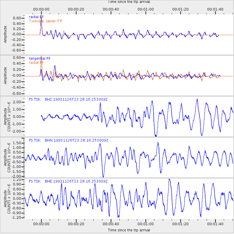
Signal To Noise
| Channel | StoN | STA | LTA |
| PS:TSK: :BHN:19931126T23:28:16.253009Z | 1.9851365 | 3.6166682E-7 | 1.8218739E-7 |
| PS:TSK: :BHE:19931126T23:28:16.253009Z | 1.8302426 | 2.5128358E-7 | 1.3729523E-7 |
| PS:TSK: :BHZ:19931126T23:28:16.253009Z | 3.0453057 | 6.80515E-7 | 2.234636E-7 |
| Arrivals |
| Ps | 3.3 SECOND |
| PpPs | 8.5 SECOND |
| PsPs/PpSs | 12 SECOND |


