You are here: Home > Network List > PS - Pacific21 Stations List
> Station TSK Tsukuba, Japan > Earthquake Result Viewer
TSK Tsukuba, Japan - Earthquake Result Viewer

| Earthquake location: |
Kermadec Islands Region |
| Earthquake latitude/longitude: |
-28.6/-176.9 |
| Earthquake time(UTC): |
1993/06/18 (169) 11:52:37 GMT |
| Earthquake Depth: |
33 km |
| Earthquake Magnitude: |
5.6 MB |
| Earthquake Catalog/Contributor: |
WHDF/NEIC |
|
| Network: |
PS Pacific21 |
| Station: |
TSK Tsukuba, Japan |
| Lat/Lon: |
36.21 N/140.11 E |
| Elevation: |
350 m |
|
| Distance: |
76.1 deg |
| Az: |
325.419 deg |
| Baz: |
141.904 deg |
| Ray Param: |
0.051173065 |
| Estimated Moho Depth: |
51.25 km |
| Estimated Crust Vp/Vs: |
1.74 |
| Assumed Crust Vp: |
6.24 km/s |
| Estimated Crust Vs: |
3.597 km/s |
| Estimated Crust Poisson's Ratio: |
0.25 |
|
| Radial Match: |
95.323296 % |
| Radial Bump: |
400 |
| Transverse Match: |
89.55245 % |
| Transverse Bump: |
400 |
| SOD ConfigId: |
17000 |
| Insert Time: |
2010-02-27 03:51:40.792 +0000 |
| GWidth: |
2.5 |
| Max Bumps: |
400 |
| Tol: |
0.001 |
|
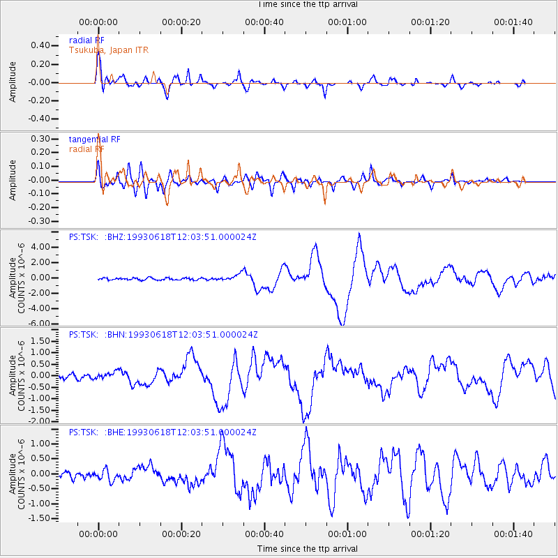
Signal To Noise
| Channel | StoN | STA | LTA |
| PS:TSK: :BHN:19930618T12:03:51.000024Z | 1.8561746 | 1.5959819E-7 | 8.5982315E-8 |
| PS:TSK: :BHE:19930618T12:03:51.000024Z | 1.3569407 | 1.8344201E-7 | 1.3518793E-7 |
| PS:TSK: :BHZ:19930618T12:03:51.000024Z | 3.702959 | 4.8382697E-7 | 1.3065956E-7 |
| Arrivals |
| Ps | 6.2 SECOND |
| PpPs | 22 SECOND |
| PsPs/PpSs | 28 SECOND |


