You are here: Home > Network List > PS - Pacific21 Stations List
> Station TSK Tsukuba, Japan > Earthquake Result Viewer
TSK Tsukuba, Japan - Earthquake Result Viewer
| Earthquake location: |
Oregon |
| Earthquake latitude/longitude: |
42.3/-122.0 |
| Earthquake time(UTC): |
1993/09/21 (264) 03:28:55 GMT |
| Earthquake Depth: |
11 km |
| Earthquake Magnitude: |
5.8 MB, 5.8 MS, 5.9 UNKNOWN, 5.9 ML |
| Earthquake Catalog/Contributor: |
WHDF/NEIC |
|
| Network: |
PS Pacific21 |
| Station: |
TSK Tsukuba, Japan |
| Lat/Lon: |
36.21 N/140.11 E |
| Elevation: |
350 m |
|
| Distance: |
71.8 deg |
| Az: |
302.517 deg |
| Baz: |
50.658 deg |
| Ray Param: |
0.054078393 |
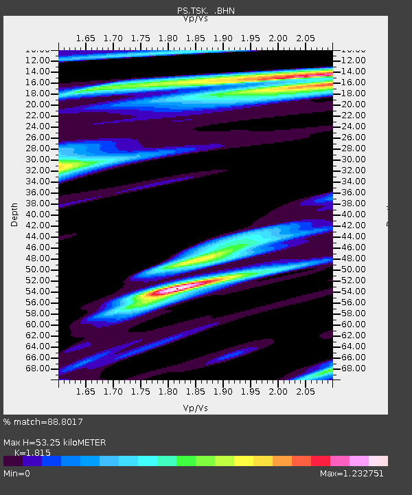
| Estimated Moho Depth: |
53.25 km |
| Estimated Crust Vp/Vs: |
1.82 |
| Assumed Crust Vp: |
6.24 km/s |
| Estimated Crust Vs: |
3.438 km/s |
| Estimated Crust Poisson's Ratio: |
0.28 |
|
| Radial Match: |
88.8017 % |
| Radial Bump: |
400 |
| Transverse Match: |
84.852356 % |
| Transverse Bump: |
400 |
| SOD ConfigId: |
17000 |
| Insert Time: |
2010-02-27 03:51:42.586 +0000 |
| GWidth: |
2.5 |
| Max Bumps: |
400 |
| Tol: |
0.001 |
|

Signal To Noise
| Channel | StoN | STA | LTA |
| PS:TSK: :BHN:19930921T03:39:46.852014Z | 2.4730806 | 1.4845222E-7 | 6.002725E-8 |
| PS:TSK: :BHE:19930921T03:39:46.852014Z | 2.3442671 | 2.2944607E-7 | 9.78754E-8 |
| PS:TSK: :BHZ:19930921T03:39:46.852014Z | 4.09529 | 4.66674E-7 | 1.13953824E-7 |
| Arrivals |
| Ps | 7.2 SECOND |
| PpPs | 23 SECOND |
| PsPs/PpSs | 30 SECOND |


