You are here: Home > Network List > AK - Alaska Regional Network Stations List
> Station SCM Sheep Mountain > Earthquake Result Viewer
SCM Sheep Mountain - Earthquake Result Viewer
| Earthquake location: |
South Of Fiji Islands |
| Earthquake latitude/longitude: |
-23.0/-177.2 |
| Earthquake time(UTC): |
2013/05/23 (143) 17:19:04 GMT |
| Earthquake Depth: |
174 km |
| Earthquake Magnitude: |
7.4 MW, 6.6 MB, 7.4 MW |
| Earthquake Catalog/Contributor: |
NEIC PDE/NEIC PDE-W |
|
| Network: |
AK Alaska Regional Network |
| Station: |
SCM Sheep Mountain |
| Lat/Lon: |
61.83 N/147.33 W |
| Elevation: |
1056 m |
|
| Distance: |
87.9 deg |
| Az: |
13.694 deg |
| Baz: |
207.367 deg |
| Ray Param: |
0.042598564 |
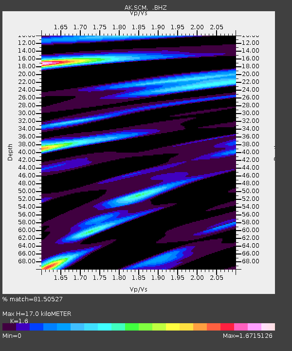
| Estimated Moho Depth: |
17.0 km |
| Estimated Crust Vp/Vs: |
1.60 |
| Assumed Crust Vp: |
6.566 km/s |
| Estimated Crust Vs: |
4.104 km/s |
| Estimated Crust Poisson's Ratio: |
0.18 |
|
| Radial Match: |
81.50527 % |
| Radial Bump: |
400 |
| Transverse Match: |
75.496185 % |
| Transverse Bump: |
400 |
| SOD ConfigId: |
512894 |
| Insert Time: |
2013-09-14 15:46:30.252 +0000 |
| GWidth: |
2.5 |
| Max Bumps: |
400 |
| Tol: |
0.001 |
|

Signal To Noise
| Channel | StoN | STA | LTA |
| AK:SCM: :BHZ:20130523T17:31:03.348022Z | 63.15549 | 9.5201885E-6 | 1.5074205E-7 |
| AK:SCM: :BHN:20130523T17:31:03.348022Z | 21.134968 | 2.3133043E-6 | 1.09453886E-7 |
| AK:SCM: :BHE:20130523T17:31:03.348022Z | 22.563786 | 2.3135399E-6 | 1.0253331E-7 |
| Arrivals |
| Ps | 1.6 SECOND |
| PpPs | 6.6 SECOND |
| PsPs/PpSs | 8.2 SECOND |


