You are here: Home > Network List > PS - Pacific21 Stations List
> Station TSK Tsukuba, Japan > Earthquake Result Viewer
TSK Tsukuba, Japan - Earthquake Result Viewer

| Earthquake location: |
Irian Jaya, Indonesia |
| Earthquake latitude/longitude: |
-3.2/136.0 |
| Earthquake time(UTC): |
1994/01/19 (019) 01:53:36 GMT |
| Earthquake Depth: |
33 km |
| Earthquake Magnitude: |
6.0 MB, 6.9 MS, 6.9 UNKNOWN |
| Earthquake Catalog/Contributor: |
WHDF/NEIC |
|
| Network: |
PS Pacific21 |
| Station: |
TSK Tsukuba, Japan |
| Lat/Lon: |
36.21 N/140.11 E |
| Elevation: |
350 m |
|
| Distance: |
39.4 deg |
| Az: |
5.208 deg |
| Baz: |
186.435 deg |
| Ray Param: |
0.074941985 |
| Estimated Moho Depth: |
20.5 km |
| Estimated Crust Vp/Vs: |
1.87 |
| Assumed Crust Vp: |
6.24 km/s |
| Estimated Crust Vs: |
3.337 km/s |
| Estimated Crust Poisson's Ratio: |
0.30 |
|
| Radial Match: |
84.779686 % |
| Radial Bump: |
400 |
| Transverse Match: |
75.56796 % |
| Transverse Bump: |
400 |
| SOD ConfigId: |
16938 |
| Insert Time: |
2010-02-27 03:51:47.660 +0000 |
| GWidth: |
2.5 |
| Max Bumps: |
400 |
| Tol: |
0.001 |
|
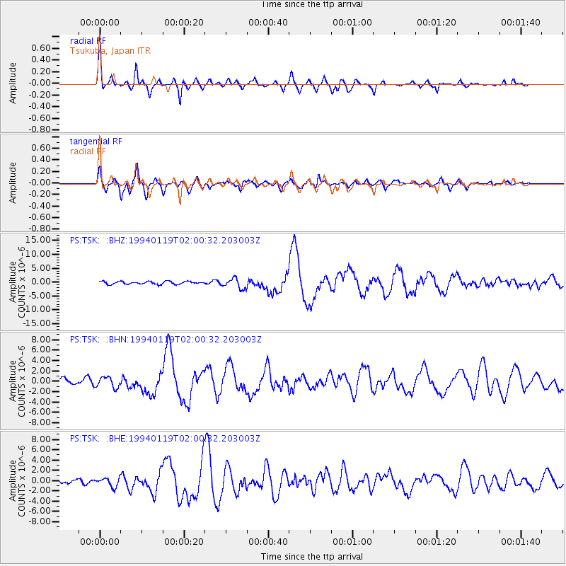
Signal To Noise
| Channel | StoN | STA | LTA |
| PS:TSK: :BHN:19940119T02:00:32.203003Z | 1.6733261 | 9.98701E-7 | 5.9683583E-7 |
| PS:TSK: :BHE:19940119T02:00:32.203003Z | 2.688499 | 8.7511955E-7 | 3.2550486E-7 |
| PS:TSK: :BHZ:19940119T02:00:32.203003Z | 3.6951818 | 1.8448305E-6 | 4.9925296E-7 |
| Arrivals |
| Ps | 3.0 SECOND |
| PpPs | 8.9 SECOND |
| PsPs/PpSs | 12 SECOND |


