You are here: Home > Network List > AK - Alaska Regional Network Stations List
> Station WAT4 Susitna Watana 4, AK, USA > Earthquake Result Viewer
WAT4 Susitna Watana 4, AK, USA - Earthquake Result Viewer
| Earthquake location: |
South Of Fiji Islands |
| Earthquake latitude/longitude: |
-23.0/-177.2 |
| Earthquake time(UTC): |
2013/05/23 (143) 17:19:04 GMT |
| Earthquake Depth: |
174 km |
| Earthquake Magnitude: |
7.4 MW, 6.6 MB, 7.4 MW |
| Earthquake Catalog/Contributor: |
NEIC PDE/NEIC PDE-W |
|
| Network: |
AK Alaska Regional Network |
| Station: |
WAT4 Susitna Watana 4, AK, USA |
| Lat/Lon: |
62.83 N/147.94 W |
| Elevation: |
1191 m |
|
| Distance: |
88.7 deg |
| Az: |
12.98 deg |
| Baz: |
206.801 deg |
| Ray Param: |
0.042038847 |
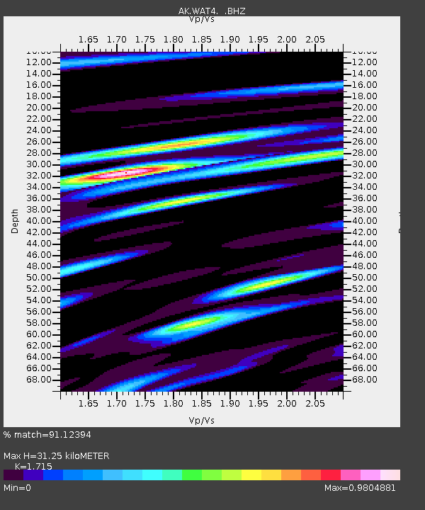
| Estimated Moho Depth: |
31.25 km |
| Estimated Crust Vp/Vs: |
1.72 |
| Assumed Crust Vp: |
6.566 km/s |
| Estimated Crust Vs: |
3.829 km/s |
| Estimated Crust Poisson's Ratio: |
0.24 |
|
| Radial Match: |
91.12394 % |
| Radial Bump: |
400 |
| Transverse Match: |
81.349236 % |
| Transverse Bump: |
400 |
| SOD ConfigId: |
512894 |
| Insert Time: |
2013-09-14 15:47:02.511 +0000 |
| GWidth: |
2.5 |
| Max Bumps: |
400 |
| Tol: |
0.001 |
|

Signal To Noise
| Channel | StoN | STA | LTA |
| AK:WAT4: :BHZ:20130523T17:31:06.947998Z | 48.39375 | 5.969694E-6 | 1.2335671E-7 |
| AK:WAT4: :BHN:20130523T17:31:06.947998Z | 36.177494 | 2.003198E-6 | 5.5371387E-8 |
| AK:WAT4: :BHE:20130523T17:31:06.947998Z | 17.737343 | 1.3211277E-6 | 7.448284E-8 |
| Arrivals |
| Ps | 3.5 SECOND |
| PpPs | 13 SECOND |
| PsPs/PpSs | 16 SECOND |


