You are here: Home > Network List > PS - Pacific21 Stations List
> Station TSK Tsukuba, Japan > Earthquake Result Viewer
TSK Tsukuba, Japan - Earthquake Result Viewer

| Earthquake location: |
Solomon Islands |
| Earthquake latitude/longitude: |
-5.7/154.1 |
| Earthquake time(UTC): |
1994/04/21 (111) 03:51:44 GMT |
| Earthquake Depth: |
30 km |
| Earthquake Magnitude: |
5.8 MB, 6.6 MS, 6.7 UNKNOWN, 6.6 MW |
| Earthquake Catalog/Contributor: |
WHDF/NEIC |
|
| Network: |
PS Pacific21 |
| Station: |
TSK Tsukuba, Japan |
| Lat/Lon: |
36.21 N/140.11 E |
| Elevation: |
350 m |
|
| Distance: |
43.7 deg |
| Az: |
343.581 deg |
| Baz: |
159.647 deg |
| Ray Param: |
0.07232065 |
| Estimated Moho Depth: |
12.0 km |
| Estimated Crust Vp/Vs: |
1.93 |
| Assumed Crust Vp: |
6.24 km/s |
| Estimated Crust Vs: |
3.225 km/s |
| Estimated Crust Poisson's Ratio: |
0.32 |
|
| Radial Match: |
89.04282 % |
| Radial Bump: |
400 |
| Transverse Match: |
78.373985 % |
| Transverse Bump: |
400 |
| SOD ConfigId: |
16938 |
| Insert Time: |
2010-02-27 03:51:54.925 +0000 |
| GWidth: |
2.5 |
| Max Bumps: |
400 |
| Tol: |
0.001 |
|
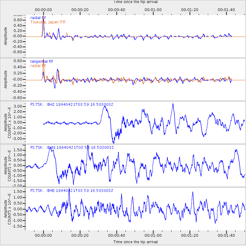
Signal To Noise
| Channel | StoN | STA | LTA |
| PS:TSK: :BHN:19940421T03:59:16.503003Z | 8.780477 | 1.0254109E-6 | 1.1678306E-7 |
| PS:TSK: :BHE:19940421T03:59:16.503003Z | 2.1870513 | 2.5548115E-7 | 1.1681534E-7 |
| PS:TSK: :BHZ:19940421T03:59:16.503003Z | 15.614878 | 1.866813E-6 | 1.1955349E-7 |
| Arrivals |
| Ps | 1.9 SECOND |
| PpPs | 5.3 SECOND |
| PsPs/PpSs | 7.2 SECOND |


