You are here: Home > Network List > PS - Pacific21 Stations List
> Station TSK Tsukuba, Japan > Earthquake Result Viewer
TSK Tsukuba, Japan - Earthquake Result Viewer

| Earthquake location: |
South Of Java, Indonesia |
| Earthquake latitude/longitude: |
-10.5/112.9 |
| Earthquake time(UTC): |
1994/06/03 (154) 21:06:57 GMT |
| Earthquake Depth: |
16 km |
| Earthquake Magnitude: |
5.9 MB, 6.4 MS, 6.3 UNKNOWN, 6.6 MW |
| Earthquake Catalog/Contributor: |
WHDF/NEIC |
|
| Network: |
PS Pacific21 |
| Station: |
TSK Tsukuba, Japan |
| Lat/Lon: |
36.21 N/140.11 E |
| Elevation: |
350 m |
|
| Distance: |
53.1 deg |
| Az: |
27.581 deg |
| Baz: |
214.267 deg |
| Ray Param: |
0.06633001 |
| Estimated Moho Depth: |
23.0 km |
| Estimated Crust Vp/Vs: |
1.70 |
| Assumed Crust Vp: |
6.24 km/s |
| Estimated Crust Vs: |
3.681 km/s |
| Estimated Crust Poisson's Ratio: |
0.23 |
|
| Radial Match: |
85.89956 % |
| Radial Bump: |
400 |
| Transverse Match: |
78.837425 % |
| Transverse Bump: |
400 |
| SOD ConfigId: |
16938 |
| Insert Time: |
2010-02-27 03:52:06.317 +0000 |
| GWidth: |
2.5 |
| Max Bumps: |
400 |
| Tol: |
0.001 |
|
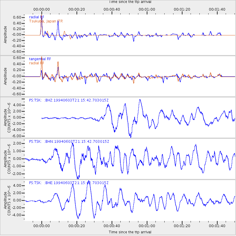
Signal To Noise
| Channel | StoN | STA | LTA |
| PS:TSK: :BHN:19940603T21:15:42.703015Z | 2.7586021 | 2.1389339E-7 | 7.7536875E-8 |
| PS:TSK: :BHE:19940603T21:15:42.703015Z | 3.3917038 | 2.7432714E-7 | 8.0881804E-8 |
| PS:TSK: :BHZ:19940603T21:15:42.703015Z | 4.2930365 | 5.359061E-7 | 1.2483147E-7 |
| Arrivals |
| Ps | 2.7 SECOND |
| PpPs | 9.4 SECOND |
| PsPs/PpSs | 12 SECOND |


