You are here: Home > Network List > BK - Berkeley Digital Seismograph Network Stations List
> Station MCCM Marconi Conference Center, Marshall, CA, USA > Earthquake Result Viewer
MCCM Marconi Conference Center, Marshall, CA, USA - Earthquake Result Viewer
| Earthquake location: |
South Of Fiji Islands |
| Earthquake latitude/longitude: |
-23.0/-177.2 |
| Earthquake time(UTC): |
2013/05/23 (143) 17:19:04 GMT |
| Earthquake Depth: |
174 km |
| Earthquake Magnitude: |
7.4 MW, 6.6 MB, 7.4 MW |
| Earthquake Catalog/Contributor: |
NEIC PDE/NEIC PDE-W |
|
| Network: |
BK Berkeley Digital Seismograph Network |
| Station: |
MCCM Marconi Conference Center, Marshall, CA, USA |
| Lat/Lon: |
38.14 N/122.88 W |
| Elevation: |
-7.7 m |
|
| Distance: |
79.4 deg |
| Az: |
40.684 deg |
| Baz: |
229.621 deg |
| Ray Param: |
0.048575312 |
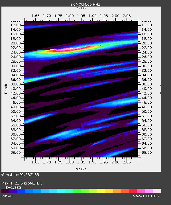
| Estimated Moho Depth: |
21.5 km |
| Estimated Crust Vp/Vs: |
1.84 |
| Assumed Crust Vp: |
6.472 km/s |
| Estimated Crust Vs: |
3.527 km/s |
| Estimated Crust Poisson's Ratio: |
0.29 |
|
| Radial Match: |
91.853165 % |
| Radial Bump: |
400 |
| Transverse Match: |
82.78519 % |
| Transverse Bump: |
400 |
| SOD ConfigId: |
512894 |
| Insert Time: |
2013-09-14 15:51:20.039 +0000 |
| GWidth: |
2.5 |
| Max Bumps: |
400 |
| Tol: |
0.001 |
|

Signal To Noise
| Channel | StoN | STA | LTA |
| BK:MCCM:00:HHZ:20130523T17:30:20.288025Z | 2.0360641 | 1.2559661E-6 | 6.168598E-7 |
| BK:MCCM:00:HHN:20130523T17:30:20.288025Z | 1.3703434 | 1.0253515E-6 | 7.4824413E-7 |
| BK:MCCM:00:HHE:20130523T17:30:20.288025Z | 1.2539037 | 9.2367526E-7 | 7.3663966E-7 |
| Arrivals |
| Ps | 2.9 SECOND |
| PpPs | 9.2 SECOND |
| PsPs/PpSs | 12 SECOND |


