You are here: Home > Network List > C - Chilean National Seismic Network Stations List
> Station GO02 Mina Guanaco, Chile > Earthquake Result Viewer
GO02 Mina Guanaco, Chile - Earthquake Result Viewer
| Earthquake location: |
South Of Fiji Islands |
| Earthquake latitude/longitude: |
-23.0/-177.2 |
| Earthquake time(UTC): |
2013/05/23 (143) 17:19:04 GMT |
| Earthquake Depth: |
174 km |
| Earthquake Magnitude: |
7.4 MW, 6.6 MB, 7.4 MW |
| Earthquake Catalog/Contributor: |
NEIC PDE/NEIC PDE-W |
|
| Network: |
C Chilean National Seismic Network |
| Station: |
GO02 Mina Guanaco, Chile |
| Lat/Lon: |
25.16 S/69.59 W |
| Elevation: |
2556 m |
|
| Distance: |
95.1 deg |
| Az: |
119.888 deg |
| Baz: |
241.827 deg |
| Ray Param: |
0.040739756 |
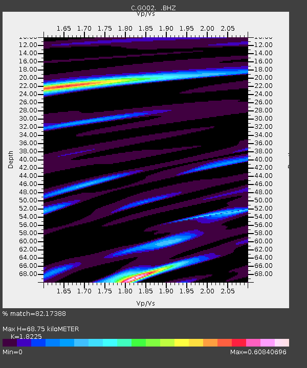
| Estimated Moho Depth: |
68.75 km |
| Estimated Crust Vp/Vs: |
1.82 |
| Assumed Crust Vp: |
6.475 km/s |
| Estimated Crust Vs: |
3.553 km/s |
| Estimated Crust Poisson's Ratio: |
0.28 |
|
| Radial Match: |
82.17388 % |
| Radial Bump: |
400 |
| Transverse Match: |
69.83213 % |
| Transverse Bump: |
400 |
| SOD ConfigId: |
512894 |
| Insert Time: |
2013-09-14 15:51:35.975 +0000 |
| GWidth: |
2.5 |
| Max Bumps: |
400 |
| Tol: |
0.001 |
|

Signal To Noise
| Channel | StoN | STA | LTA |
| C:GO02: :BHZ:20130523T17:31:36.525024Z | 3.900049 | 2.5639633E-6 | 6.5741824E-7 |
| C:GO02: :BHN:20130523T17:31:36.525024Z | 1.1038572 | 3.4827357E-7 | 3.15506E-7 |
| C:GO02: :BHE:20130523T17:31:36.525024Z | 0.7869937 | 5.977049E-7 | 7.5947867E-7 |
| Arrivals |
| Ps | 8.9 SECOND |
| PpPs | 29 SECOND |
| PsPs/PpSs | 38 SECOND |


