You are here: Home > Network List > C - Chilean National Seismic Network Stations List
> Station GO09 Cerro Castillo, Chile > Earthquake Result Viewer
GO09 Cerro Castillo, Chile - Earthquake Result Viewer
| Earthquake location: |
South Of Fiji Islands |
| Earthquake latitude/longitude: |
-23.0/-177.2 |
| Earthquake time(UTC): |
2013/05/23 (143) 17:19:04 GMT |
| Earthquake Depth: |
174 km |
| Earthquake Magnitude: |
7.4 MW, 6.6 MB, 7.4 MW |
| Earthquake Catalog/Contributor: |
NEIC PDE/NEIC PDE-W |
|
| Network: |
C Chilean National Seismic Network |
| Station: |
GO09 Cerro Castillo, Chile |
| Lat/Lon: |
51.27 S/72.34 W |
| Elevation: |
372 m |
|
| Distance: |
81.2 deg |
| Az: |
142.093 deg |
| Baz: |
244.306 deg |
| Ray Param: |
0.047354583 |
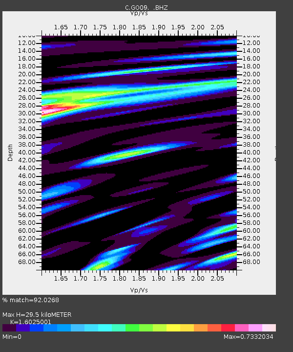
| Estimated Moho Depth: |
29.5 km |
| Estimated Crust Vp/Vs: |
1.60 |
| Assumed Crust Vp: |
6.438 km/s |
| Estimated Crust Vs: |
4.018 km/s |
| Estimated Crust Poisson's Ratio: |
0.18 |
|
| Radial Match: |
92.0268 % |
| Radial Bump: |
400 |
| Transverse Match: |
79.901 % |
| Transverse Bump: |
400 |
| SOD ConfigId: |
512894 |
| Insert Time: |
2013-09-14 15:51:55.668 +0000 |
| GWidth: |
2.5 |
| Max Bumps: |
400 |
| Tol: |
0.001 |
|

Signal To Noise
| Channel | StoN | STA | LTA |
| C:GO09: :BHZ:20130523T17:30:29.775024Z | 6.632758 | 9.264762E-6 | 1.3968189E-6 |
| C:GO09: :BHN:20130523T17:30:29.775024Z | 0.8880491 | 1.4034956E-6 | 1.5804256E-6 |
| C:GO09: :BHE:20130523T17:30:29.775024Z | 2.8027446 | 3.0549133E-6 | 1.089972E-6 |
| Arrivals |
| Ps | 2.8 SECOND |
| PpPs | 12 SECOND |
| PsPs/PpSs | 14 SECOND |


