You are here: Home > Network List > PS - Pacific21 Stations List
> Station TSK Tsukuba, Japan > Earthquake Result Viewer
TSK Tsukuba, Japan - Earthquake Result Viewer
| Earthquake location: |
Santa Cruz Islands |
| Earthquake latitude/longitude: |
-11.5/166.4 |
| Earthquake time(UTC): |
1994/08/22 (234) 17:26:38 GMT |
| Earthquake Depth: |
148 km |
| Earthquake Magnitude: |
6.1 MB, 6.4 UNKNOWN, 6.1 MW |
| Earthquake Catalog/Contributor: |
WHDF/NEIC |
|
| Network: |
PS Pacific21 |
| Station: |
TSK Tsukuba, Japan |
| Lat/Lon: |
36.21 N/140.11 E |
| Elevation: |
350 m |
|
| Distance: |
53.5 deg |
| Az: |
333.539 deg |
| Baz: |
147.312 deg |
| Ray Param: |
0.06553146 |
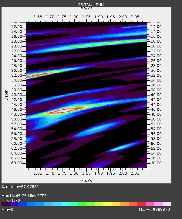
| Estimated Moho Depth: |
46.25 km |
| Estimated Crust Vp/Vs: |
1.76 |
| Assumed Crust Vp: |
6.24 km/s |
| Estimated Crust Vs: |
3.545 km/s |
| Estimated Crust Poisson's Ratio: |
0.26 |
|
| Radial Match: |
87.07931 % |
| Radial Bump: |
400 |
| Transverse Match: |
68.97525 % |
| Transverse Bump: |
343 |
| SOD ConfigId: |
17000 |
| Insert Time: |
2010-02-27 03:52:15.874 +0000 |
| GWidth: |
2.5 |
| Max Bumps: |
400 |
| Tol: |
0.001 |
|
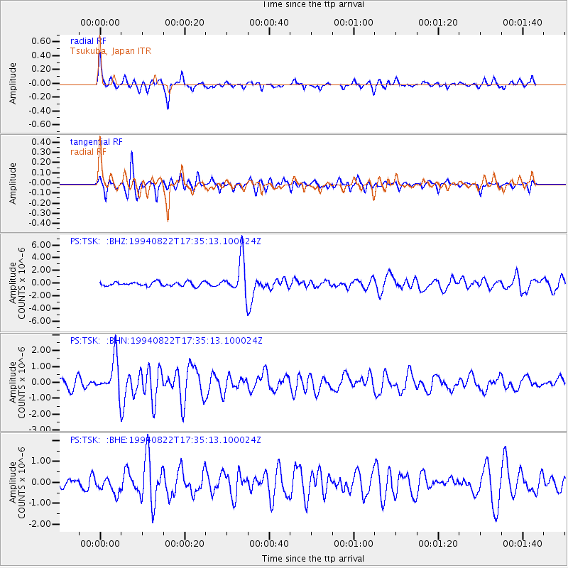
Signal To Noise
| Channel | StoN | STA | LTA |
| PS:TSK: :BHN:19940822T17:35:13.100024Z | 3.8426402 | 1.1660003E-6 | 3.0343728E-7 |
| PS:TSK: :BHE:19940822T17:35:13.100024Z | 1.5365373 | 3.7518944E-7 | 2.4417855E-7 |
| PS:TSK: :BHZ:19940822T17:35:13.100024Z | 9.12942 | 2.8692896E-6 | 3.1429045E-7 |
| Arrivals |
| Ps | 5.9 SECOND |
| PpPs | 19 SECOND |
| PsPs/PpSs | 25 SECOND |


