You are here: Home > Network List > CB - China National Seismic Network Stations List
> Station HEH Heihe,Heilongjiang Province > Earthquake Result Viewer
HEH Heihe,Heilongjiang Province - Earthquake Result Viewer
| Earthquake location: |
South Of Fiji Islands |
| Earthquake latitude/longitude: |
-23.0/-177.2 |
| Earthquake time(UTC): |
2013/05/23 (143) 17:19:04 GMT |
| Earthquake Depth: |
174 km |
| Earthquake Magnitude: |
7.4 MW, 6.6 MB, 7.4 MW |
| Earthquake Catalog/Contributor: |
NEIC PDE/NEIC PDE-W |
|
| Network: |
CB China National Seismic Network |
| Station: |
HEH Heihe,Heilongjiang Province |
| Lat/Lon: |
50.25 N/127.41 E |
| Elevation: |
165 m |
|
| Distance: |
87.8 deg |
| Az: |
328.095 deg |
| Baz: |
130.66 deg |
| Ray Param: |
0.04265456 |
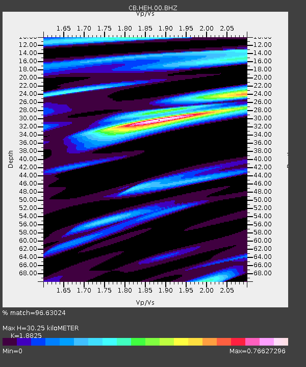
| Estimated Moho Depth: |
30.25 km |
| Estimated Crust Vp/Vs: |
1.88 |
| Assumed Crust Vp: |
6.419 km/s |
| Estimated Crust Vs: |
3.41 km/s |
| Estimated Crust Poisson's Ratio: |
0.30 |
|
| Radial Match: |
96.63024 % |
| Radial Bump: |
374 |
| Transverse Match: |
94.39081 % |
| Transverse Bump: |
396 |
| SOD ConfigId: |
512894 |
| Insert Time: |
2013-09-14 15:52:16.124 +0000 |
| GWidth: |
2.5 |
| Max Bumps: |
400 |
| Tol: |
0.001 |
|
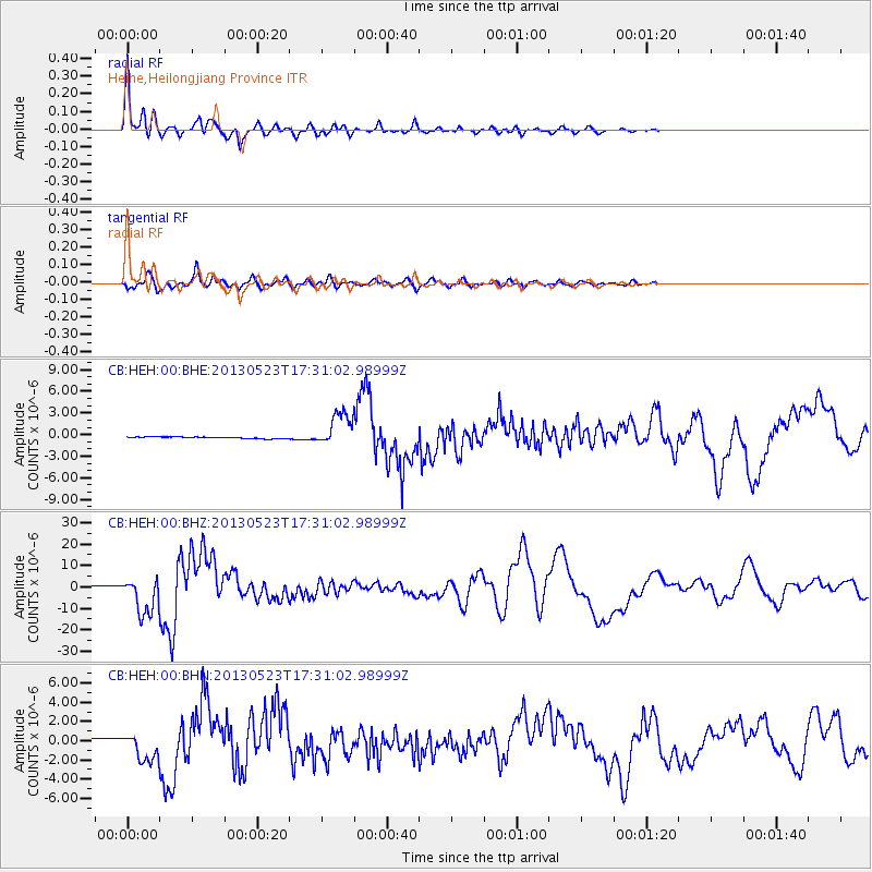
Signal To Noise
| Channel | StoN | STA | LTA |
| CB:HEH:00:BHZ:20130523T17:31:02.98999Z | 15.008985 | 8.562398E-6 | 5.704848E-7 |
| CB:HEH:00:BHN:20130523T17:31:02.98999Z | 19.462843 | 1.5445795E-6 | 7.9360426E-8 |
| CB:HEH:00:BHE:20130523T17:31:02.98999Z | 21.30118 | 2.3169316E-6 | 1.087701E-7 |
| Arrivals |
| Ps | 4.2 SECOND |
| PpPs | 13 SECOND |
| PsPs/PpSs | 18 SECOND |


