You are here: Home > Network List > CB - China National Seismic Network Stations List
> Station WHN Wuhantai,Hubei Province > Earthquake Result Viewer
WHN Wuhantai,Hubei Province - Earthquake Result Viewer
| Earthquake location: |
South Of Fiji Islands |
| Earthquake latitude/longitude: |
-23.0/-177.2 |
| Earthquake time(UTC): |
2013/05/23 (143) 17:19:04 GMT |
| Earthquake Depth: |
174 km |
| Earthquake Magnitude: |
7.4 MW, 6.6 MB, 7.4 MW |
| Earthquake Catalog/Contributor: |
NEIC PDE/NEIC PDE-W |
|
| Network: |
CB China National Seismic Network |
| Station: |
WHN Wuhantai,Hubei Province |
| Lat/Lon: |
30.54 N/114.35 E |
| Elevation: |
80 m |
|
| Distance: |
84.5 deg |
| Az: |
306.298 deg |
| Baz: |
120.601 deg |
| Ray Param: |
0.045031253 |
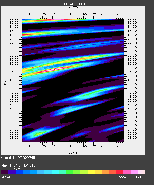
| Estimated Moho Depth: |
34.5 km |
| Estimated Crust Vp/Vs: |
1.76 |
| Assumed Crust Vp: |
6.276 km/s |
| Estimated Crust Vs: |
3.571 km/s |
| Estimated Crust Poisson's Ratio: |
0.26 |
|
| Radial Match: |
97.329765 % |
| Radial Bump: |
358 |
| Transverse Match: |
88.22034 % |
| Transverse Bump: |
400 |
| SOD ConfigId: |
512894 |
| Insert Time: |
2013-09-14 15:52:31.649 +0000 |
| GWidth: |
2.5 |
| Max Bumps: |
400 |
| Tol: |
0.001 |
|

Signal To Noise
| Channel | StoN | STA | LTA |
| CB:WHN:00:BHZ:20130523T17:30:46.859985Z | 23.398392 | 9.471372E-6 | 4.0478733E-7 |
| CB:WHN:00:BHN:20130523T17:30:46.859985Z | 9.143891 | 1.3325663E-6 | 1.4573295E-7 |
| CB:WHN:00:BHE:20130523T17:30:46.859985Z | 13.935002 | 2.5594486E-6 | 1.836705E-7 |
| Arrivals |
| Ps | 4.3 SECOND |
| PpPs | 15 SECOND |
| PsPs/PpSs | 19 SECOND |


