You are here: Home > Network List > CC - Cascade Chain Volcano Monitoring Stations List
> Station CIHL Cinder Hill, Newberry, OR > Earthquake Result Viewer
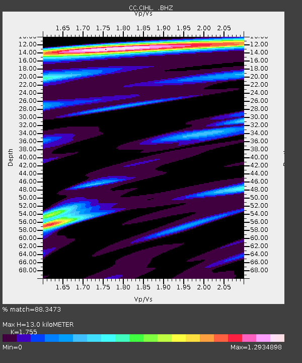
CIHL Cinder Hill, Newberry, OR - Earthquake Result Viewer
| Earthquake location: |
South Of Fiji Islands |
| Earthquake latitude/longitude: |
-23.0/-177.2 |
| Earthquake time(UTC): |
2013/05/23 (143) 17:19:04 GMT |
| Earthquake Depth: |
174 km |
| Earthquake Magnitude: |
7.4 MW, 6.6 MB, 7.4 MW |
| Earthquake Catalog/Contributor: |
NEIC PDE/NEIC PDE-W |
|
| Network: |
CC Cascade Chain Volcano Monitoring |
| Station: |
CIHL Cinder Hill, Newberry, OR |
| Lat/Lon: |
43.75 N/121.15 W |
| Elevation: |
1966 m |
|
| Distance: |
84.0 deg |
| Az: |
37.207 deg |
| Baz: |
230.25 deg |
| Ray Param: |
0.04539278 |
| Estimated Moho Depth: |
13.0 km |
| Estimated Crust Vp/Vs: |
1.75 |
| Assumed Crust Vp: |
6.597 km/s |
| Estimated Crust Vs: |
3.759 km/s |
| Estimated Crust Poisson's Ratio: |
0.26 |
|
| Radial Match: |
88.3473 % |
| Radial Bump: |
400 |
| Transverse Match: |
82.50705 % |
| Transverse Bump: |
400 |
| SOD ConfigId: |
512894 |
| Insert Time: |
2013-09-14 15:52:39.235 +0000 |
| GWidth: |
2.5 |
| Max Bumps: |
400 |
| Tol: |
0.001 |
|

Signal To Noise
| Channel | StoN | STA | LTA |
| CC:CIHL: :BHZ:20130523T17:30:44.299988Z | 7.125218 | 1.7594446E-6 | 2.4693205E-7 |
| CC:CIHL: :BHN:20130523T17:30:44.299988Z | 1.9209837 | 1.1532005E-6 | 6.003177E-7 |
| CC:CIHL: :BHE:20130523T17:30:44.299988Z | 2.776857 | 9.2234825E-7 | 3.3215548E-7 |
| Arrivals |
| Ps | 1.5 SECOND |
| PpPs | 5.3 SECOND |
| PsPs/PpSs | 6.8 SECOND |


