You are here: Home > Network List > CC - Cascade Chain Volcano Monitoring Stations List
> Station PANH Panhandle Gap, Mt. Rainier, WA > Earthquake Result Viewer
PANH Panhandle Gap, Mt. Rainier, WA - Earthquake Result Viewer
| Earthquake location: |
South Of Fiji Islands |
| Earthquake latitude/longitude: |
-23.0/-177.2 |
| Earthquake time(UTC): |
2013/05/23 (143) 17:19:04 GMT |
| Earthquake Depth: |
174 km |
| Earthquake Magnitude: |
7.4 MW, 6.6 MB, 7.4 MW |
| Earthquake Catalog/Contributor: |
NEIC PDE/NEIC PDE-W |
|
| Network: |
CC Cascade Chain Volcano Monitoring |
| Station: |
PANH Panhandle Gap, Mt. Rainier, WA |
| Lat/Lon: |
46.86 N/121.64 W |
| Elevation: |
2109 m |
|
| Distance: |
85.7 deg |
| Az: |
34.592 deg |
| Baz: |
229.665 deg |
| Ray Param: |
0.0441649 |
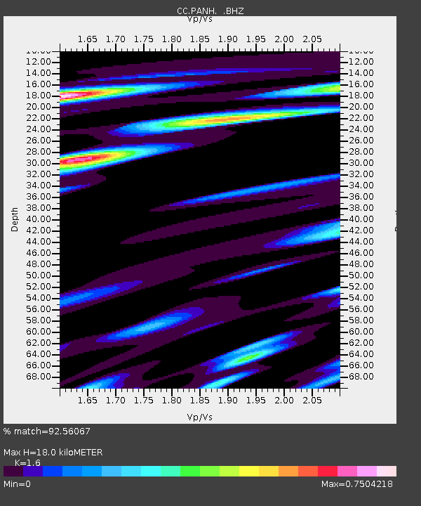
| Estimated Moho Depth: |
18.0 km |
| Estimated Crust Vp/Vs: |
1.60 |
| Assumed Crust Vp: |
6.597 km/s |
| Estimated Crust Vs: |
4.123 km/s |
| Estimated Crust Poisson's Ratio: |
0.18 |
|
| Radial Match: |
92.56067 % |
| Radial Bump: |
400 |
| Transverse Match: |
88.91748 % |
| Transverse Bump: |
400 |
| SOD ConfigId: |
512894 |
| Insert Time: |
2013-09-14 15:52:51.567 +0000 |
| GWidth: |
2.5 |
| Max Bumps: |
400 |
| Tol: |
0.001 |
|

Signal To Noise
| Channel | StoN | STA | LTA |
| CC:PANH: :BHZ:20130523T17:30:52.940002Z | 6.020097 | 2.375719E-6 | 3.9463137E-7 |
| CC:PANH: :BHN:20130523T17:30:52.940002Z | 4.2371182 | 1.13991E-6 | 2.6902956E-7 |
| CC:PANH: :BHE:20130523T17:30:52.940002Z | 2.1664307 | 6.687177E-7 | 3.0867253E-7 |
| Arrivals |
| Ps | 1.7 SECOND |
| PpPs | 6.9 SECOND |
| PsPs/PpSs | 8.6 SECOND |


