You are here: Home > Network List > CN - Canadian National Seismograph Network Stations List
> Station DIB DAWSON INLET, BC > Earthquake Result Viewer
DIB DAWSON INLET, BC - Earthquake Result Viewer
| Earthquake location: |
South Of Fiji Islands |
| Earthquake latitude/longitude: |
-23.0/-177.2 |
| Earthquake time(UTC): |
2013/05/23 (143) 17:19:04 GMT |
| Earthquake Depth: |
174 km |
| Earthquake Magnitude: |
7.4 MW, 6.6 MB, 7.4 MW |
| Earthquake Catalog/Contributor: |
NEIC PDE/NEIC PDE-W |
|
| Network: |
CN Canadian National Seismograph Network |
| Station: |
DIB DAWSON INLET, BC |
| Lat/Lon: |
53.20 N/132.48 W |
| Elevation: |
68 m |
|
| Distance: |
85.2 deg |
| Az: |
25.152 deg |
| Baz: |
220.616 deg |
| Ray Param: |
0.044508714 |
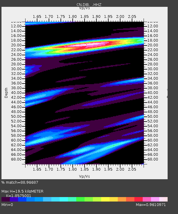
| Estimated Moho Depth: |
19.5 km |
| Estimated Crust Vp/Vs: |
1.86 |
| Assumed Crust Vp: |
6.183 km/s |
| Estimated Crust Vs: |
3.328 km/s |
| Estimated Crust Poisson's Ratio: |
0.30 |
|
| Radial Match: |
88.96687 % |
| Radial Bump: |
400 |
| Transverse Match: |
68.82894 % |
| Transverse Bump: |
400 |
| SOD ConfigId: |
512894 |
| Insert Time: |
2013-09-14 15:54:58.520 +0000 |
| GWidth: |
2.5 |
| Max Bumps: |
400 |
| Tol: |
0.001 |
|

Signal To Noise
| Channel | StoN | STA | LTA |
| CN:DIB: :HHZ:20130523T17:30:50.51001Z | 6.2751637 | 2.8543643E-6 | 4.548669E-7 |
| CN:DIB: :HHN:20130523T17:30:50.51001Z | 2.1269035 | 8.051902E-7 | 3.7857393E-7 |
| CN:DIB: :HHE:20130523T17:30:50.51001Z | 2.7216575 | 1.1376982E-6 | 4.1801667E-7 |
| Arrivals |
| Ps | 2.8 SECOND |
| PpPs | 8.8 SECOND |
| PsPs/PpSs | 12 SECOND |


