You are here: Home > Network List > CN - Canadian National Seismograph Network Stations List
> Station LLLB LILLOOET, BC, CANADA ADA > Earthquake Result Viewer
LLLB LILLOOET, BC, CANADA ADA - Earthquake Result Viewer
| Earthquake location: |
South Of Fiji Islands |
| Earthquake latitude/longitude: |
-23.0/-177.2 |
| Earthquake time(UTC): |
2013/05/23 (143) 17:19:04 GMT |
| Earthquake Depth: |
174 km |
| Earthquake Magnitude: |
7.4 MW, 6.6 MB, 7.4 MW |
| Earthquake Catalog/Contributor: |
NEIC PDE/NEIC PDE-W |
|
| Network: |
CN Canadian National Seismograph Network |
| Station: |
LLLB LILLOOET, BC, CANADA ADA |
| Lat/Lon: |
50.61 N/121.88 W |
| Elevation: |
700 m |
|
| Distance: |
88.0 deg |
| Az: |
31.632 deg |
| Baz: |
229.325 deg |
| Ray Param: |
0.042486362 |
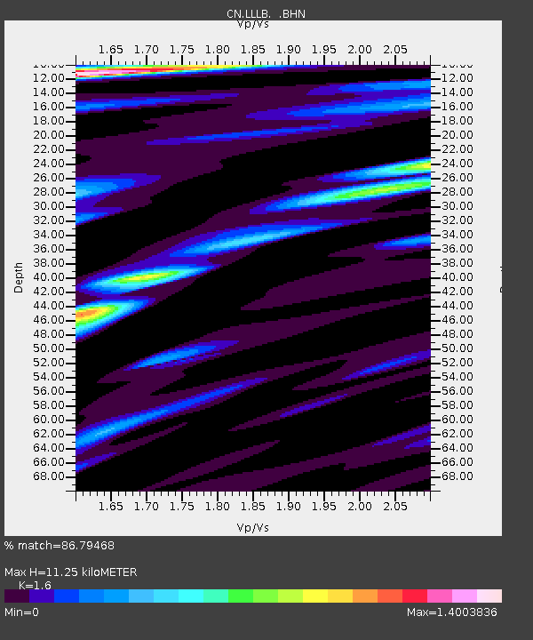
| Estimated Moho Depth: |
11.25 km |
| Estimated Crust Vp/Vs: |
1.60 |
| Assumed Crust Vp: |
6.597 km/s |
| Estimated Crust Vs: |
4.123 km/s |
| Estimated Crust Poisson's Ratio: |
0.18 |
|
| Radial Match: |
86.79468 % |
| Radial Bump: |
400 |
| Transverse Match: |
75.67586 % |
| Transverse Bump: |
400 |
| SOD ConfigId: |
512894 |
| Insert Time: |
2013-09-14 15:55:05.302 +0000 |
| GWidth: |
2.5 |
| Max Bumps: |
400 |
| Tol: |
0.001 |
|
Signal To Noise
| Channel | StoN | STA | LTA |
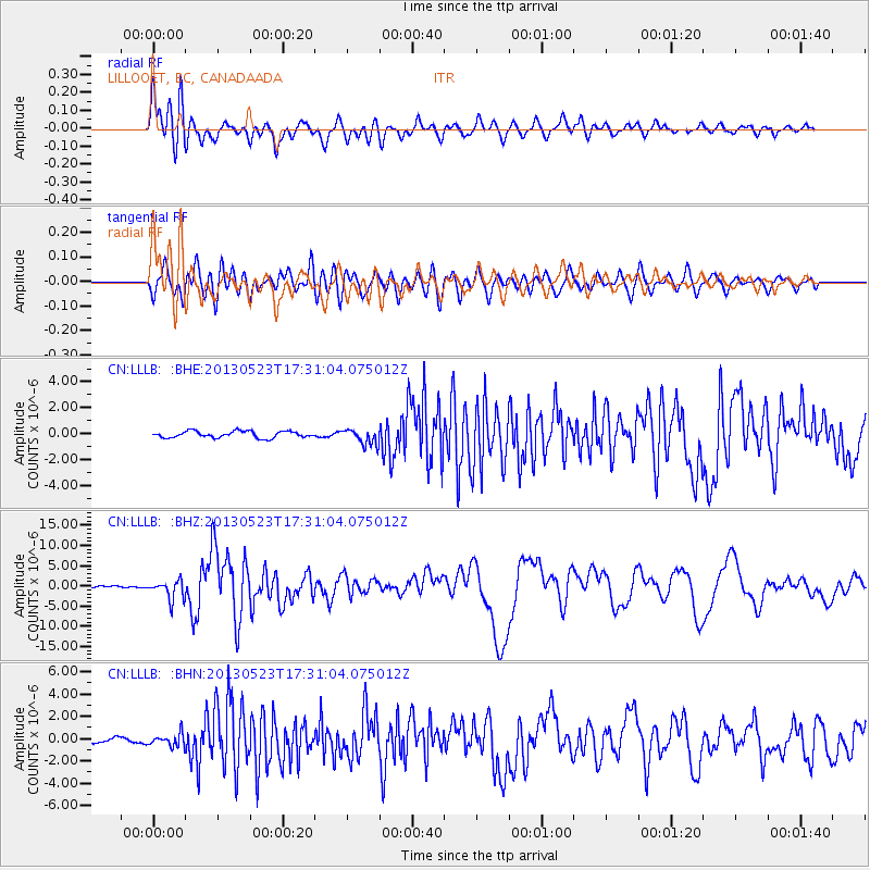
| CN:LLLB: :BHZ:20130523T17:31:04.075012Z | 9.282293 | 2.364349E-6 | 2.5471607E-7 |
| CN:LLLB: :BHN:20130523T17:31:04.075012Z | 2.240721 | 5.4067533E-7 | 2.4129525E-7 |
| CN:LLLB: :BHE:20130523T17:31:04.075012Z | 2.4056761 | 6.0765615E-7 | 2.5259266E-7 |
| Arrivals |
| Ps | 1.0 SECOND |
| PpPs | 4.3 SECOND |
| PsPs/PpSs | 5.4 SECOND |


