You are here: Home > Network List > G - GEOSCOPE Stations List
> Station TAOE Taiohae, Marquises islands > Earthquake Result Viewer
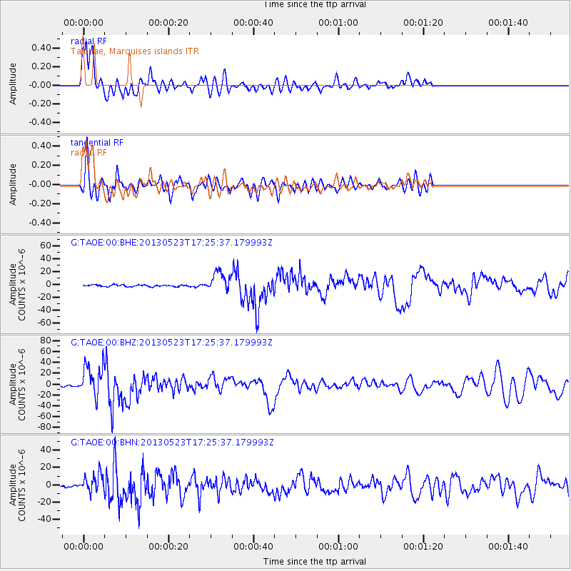
TAOE Taiohae, Marquises islands - Earthquake Result Viewer
*The percent match for this event was below the threshold and hence no stack was calculated.
| Earthquake location: |
South Of Fiji Islands |
| Earthquake latitude/longitude: |
-23.0/-177.2 |
| Earthquake time(UTC): |
2013/05/23 (143) 17:19:04 GMT |
| Earthquake Depth: |
174 km |
| Earthquake Magnitude: |
7.4 MW, 6.6 MB, 7.4 MW |
| Earthquake Catalog/Contributor: |
NEIC PDE/NEIC PDE-W |
|
| Network: |
G GEOSCOPE |
| Station: |
TAOE Taiohae, Marquises islands |
| Lat/Lon: |
8.85 S/140.15 W |
| Elevation: |
800 m |
|
| Distance: |
38.2 deg |
| Az: |
74.478 deg |
| Baz: |
243.942 deg |
| Ray Param: |
$rayparam |
*The percent match for this event was below the threshold and hence was not used in the summary stack. |
|
| Radial Match: |
90.27265 % |
| Radial Bump: |
400 |
| Transverse Match: |
78.96678 % |
| Transverse Bump: |
400 |
| SOD ConfigId: |
512894 |
| Insert Time: |
2013-09-14 15:55:58.912 +0000 |
| GWidth: |
2.5 |
| Max Bumps: |
400 |
| Tol: |
0.001 |
|
Signal To Noise
| Channel | StoN | STA | LTA |
| G:TAOE:00:BHZ:20130523T17:25:37.179993Z | 22.490108 | 2.9746108E-5 | 1.3226307E-6 |
| G:TAOE:00:BHN:20130523T17:25:37.179993Z | 9.157068 | 1.0674213E-5 | 1.1656801E-6 |
| G:TAOE:00:BHE:20130523T17:25:37.179993Z | 11.951898 | 1.5528669E-5 | 1.2992639E-6 |
| Arrivals |
| Ps | |
| PpPs | |
| PsPs/PpSs | |


