You are here: Home > Network List > GS - US Geological Survey Networks Stations List
> Station ETX08 Co Rd 4789, Timpson, TX, USA > Earthquake Result Viewer
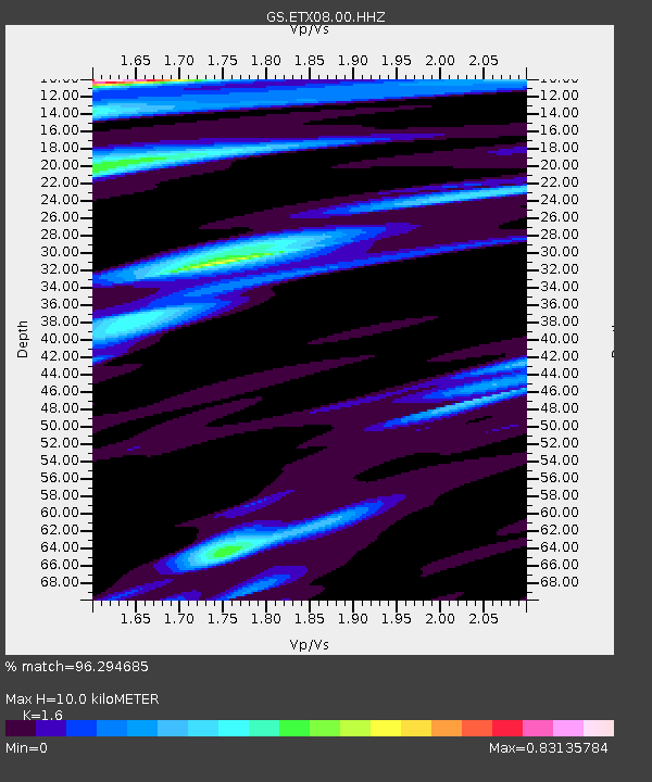
ETX08 Co Rd 4789, Timpson, TX, USA - Earthquake Result Viewer
| Earthquake location: |
South Of Fiji Islands |
| Earthquake latitude/longitude: |
-23.0/-177.2 |
| Earthquake time(UTC): |
2013/05/23 (143) 17:19:04 GMT |
| Earthquake Depth: |
174 km |
| Earthquake Magnitude: |
7.4 MW, 6.6 MB, 7.4 MW |
| Earthquake Catalog/Contributor: |
NEIC PDE/NEIC PDE-W |
|
| Network: |
GS US Geological Survey Networks |
| Station: |
ETX08 Co Rd 4789, Timpson, TX, USA |
| Lat/Lon: |
31.84 N/94.42 W |
| Elevation: |
107 m |
|
| Distance: |
96.1 deg |
| Az: |
58.128 deg |
| Baz: |
246.826 deg |
| Ray Param: |
0.04047127 |
| Estimated Moho Depth: |
10.0 km |
| Estimated Crust Vp/Vs: |
1.60 |
| Assumed Crust Vp: |
5.738 km/s |
| Estimated Crust Vs: |
3.587 km/s |
| Estimated Crust Poisson's Ratio: |
0.18 |
|
| Radial Match: |
96.294685 % |
| Radial Bump: |
382 |
| Transverse Match: |
81.43131 % |
| Transverse Bump: |
400 |
| SOD ConfigId: |
512894 |
| Insert Time: |
2013-09-14 15:56:25.438 +0000 |
| GWidth: |
2.5 |
| Max Bumps: |
400 |
| Tol: |
0.001 |
|

Signal To Noise
| Channel | StoN | STA | LTA |
| GS:ETX08:00:HHZ:20130523T17:31:40.994019Z | 7.192341 | 5.5878724E-7 | 7.769198E-8 |
| GS:ETX08:00:HH1:20130523T17:31:40.994019Z | 1.5420264 | 1.3553858E-7 | 8.789641E-8 |
| GS:ETX08:00:HH2:20130523T17:31:40.994019Z | 2.104414 | 2.0999069E-7 | 9.978583E-8 |
| Arrivals |
| Ps | 1.1 SECOND |
| PpPs | 4.5 SECOND |
| PsPs/PpSs | 5.5 SECOND |


