You are here: Home > Network List > HV - Hawaiian Volcano Observatory Network Stations List
> Station AIND Ainapo Ranch, Hawaii Digital > Earthquake Result Viewer
AIND Ainapo Ranch, Hawaii Digital - Earthquake Result Viewer
| Earthquake location: |
South Of Fiji Islands |
| Earthquake latitude/longitude: |
-23.0/-177.2 |
| Earthquake time(UTC): |
2013/05/23 (143) 17:19:04 GMT |
| Earthquake Depth: |
174 km |
| Earthquake Magnitude: |
7.4 MW, 6.6 MB, 7.4 MW |
| Earthquake Catalog/Contributor: |
NEIC PDE/NEIC PDE-W |
|
| Network: |
HV Hawaiian Volcano Observatory Network |
| Station: |
AIND Ainapo Ranch, Hawaii Digital |
| Lat/Lon: |
19.37 N/155.46 W |
| Elevation: |
1524 m |
|
| Distance: |
47.2 deg |
| Az: |
28.518 deg |
| Baz: |
207.772 deg |
| Ray Param: |
0.06952722 |
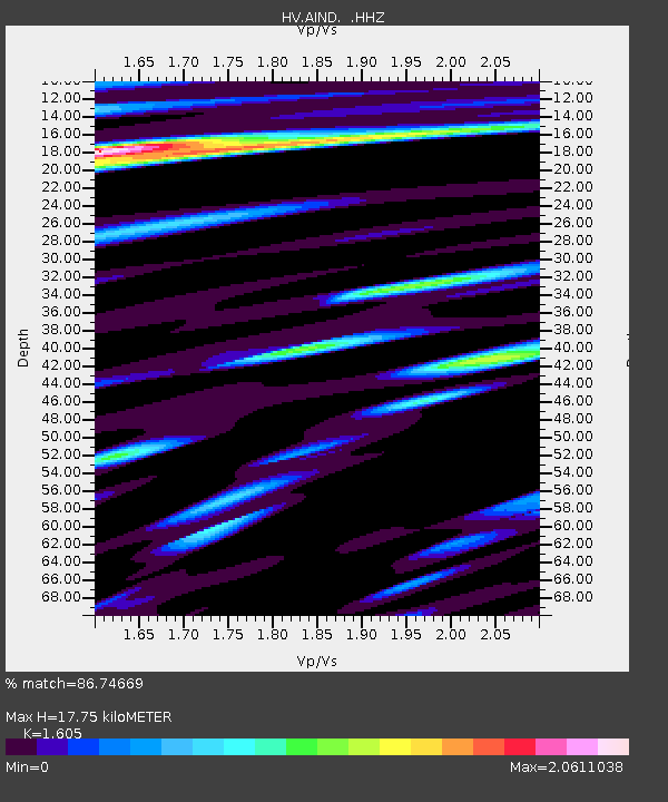
| Estimated Moho Depth: |
17.75 km |
| Estimated Crust Vp/Vs: |
1.61 |
| Assumed Crust Vp: |
5.195 km/s |
| Estimated Crust Vs: |
3.237 km/s |
| Estimated Crust Poisson's Ratio: |
0.18 |
|
| Radial Match: |
86.74669 % |
| Radial Bump: |
348 |
| Transverse Match: |
72.26393 % |
| Transverse Bump: |
400 |
| SOD ConfigId: |
512894 |
| Insert Time: |
2013-09-14 15:56:44.165 +0000 |
| GWidth: |
2.5 |
| Max Bumps: |
400 |
| Tol: |
0.001 |
|

Signal To Noise
| Channel | StoN | STA | LTA |
| HV:AIND: :HHZ:20130523T17:26:49.279999Z | 2.7637753 | 6.191185E-6 | 2.2401186E-6 |
| HV:AIND: :HHN:20130523T17:26:49.279999Z | 1.5994806 | 4.548921E-6 | 2.8439986E-6 |
| HV:AIND: :HHE:20130523T17:26:49.279999Z | 0.9878078 | 1.719732E-6 | 1.7409582E-6 |
| Arrivals |
| Ps | 2.2 SECOND |
| PpPs | 8.5 SECOND |
| PsPs/PpSs | 11 SECOND |


