You are here: Home > Network List > PS - Pacific21 Stations List
> Station TSK Tsukuba, Japan > Earthquake Result Viewer
TSK Tsukuba, Japan - Earthquake Result Viewer
| Earthquake location: |
Solomon Islands |
| Earthquake latitude/longitude: |
-5.8/154.2 |
| Earthquake time(UTC): |
1995/08/16 (228) 10:27:26 GMT |
| Earthquake Depth: |
16 km |
| Earthquake Magnitude: |
6.4 MB, 7.8 MS, 7.8 UNKNOWN, 7.8 MW |
| Earthquake Catalog/Contributor: |
WHDF/NEIC |
|
| Network: |
PS Pacific21 |
| Station: |
TSK Tsukuba, Japan |
| Lat/Lon: |
36.21 N/140.11 E |
| Elevation: |
350 m |
|
| Distance: |
43.8 deg |
| Az: |
343.472 deg |
| Baz: |
159.514 deg |
| Ray Param: |
0.07227288 |
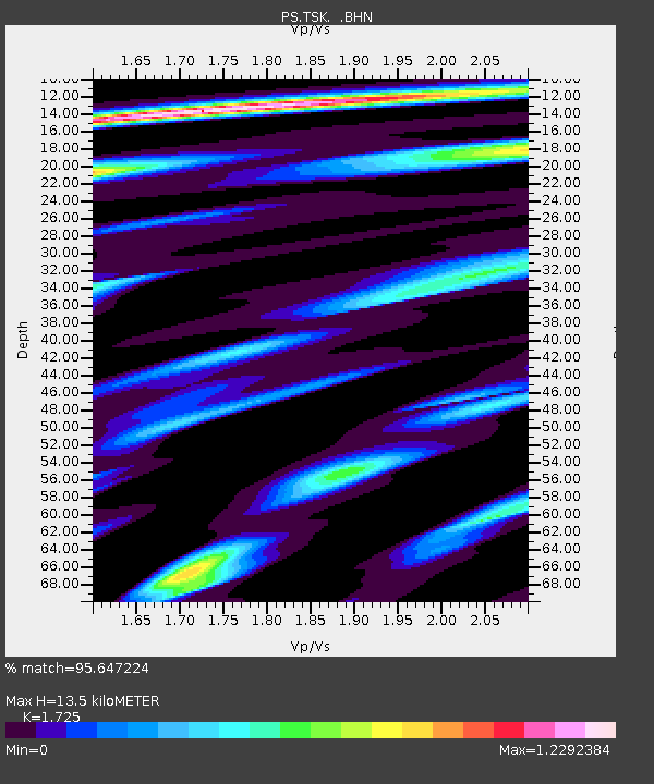
| Estimated Moho Depth: |
13.5 km |
| Estimated Crust Vp/Vs: |
1.73 |
| Assumed Crust Vp: |
6.24 km/s |
| Estimated Crust Vs: |
3.617 km/s |
| Estimated Crust Poisson's Ratio: |
0.25 |
|
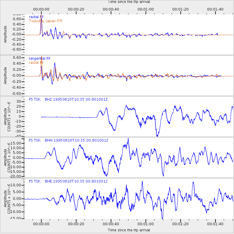
| Radial Match: |
95.647224 % |
| Radial Bump: |
400 |
| Transverse Match: |
88.90095 % |
| Transverse Bump: |
400 |
| SOD ConfigId: |
6273 |
| Insert Time: |
2010-02-27 03:52:27.902 +0000 |
| GWidth: |
2.5 |
| Max Bumps: |
400 |
| Tol: |
0.001 |
|
Signal To Noise
| Channel | StoN | STA | LTA |
| PS:TSK: :BHN:19950816T10:35:00.801001Z | 14.998194 | 3.4007521E-6 | 2.2674412E-7 |
| PS:TSK: :BHE:19950816T10:35:00.801001Z | 4.5156074 | 4.358264E-7 | 9.651557E-8 |
| PS:TSK: :BHZ:19950816T10:35:00.801001Z | 20.329325 | 6.738287E-6 | 3.314565E-7 |
| Arrivals |
| Ps | 1.7 SECOND |
| PpPs | 5.5 SECOND |
| PsPs/PpSs | 7.2 SECOND |


