You are here: Home > Network List > HV - Hawaiian Volcano Observatory Network Stations List
> Station HUAD Hualalai, Hawaii Digital > Earthquake Result Viewer
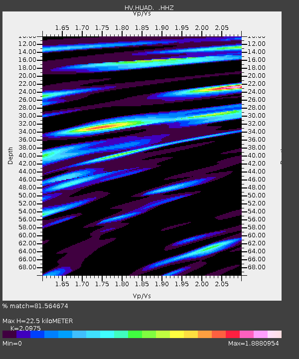
HUAD Hualalai, Hawaii Digital - Earthquake Result Viewer
| Earthquake location: |
South Of Fiji Islands |
| Earthquake latitude/longitude: |
-23.0/-177.2 |
| Earthquake time(UTC): |
2013/05/23 (143) 17:19:04 GMT |
| Earthquake Depth: |
174 km |
| Earthquake Magnitude: |
7.4 MW, 6.6 MB, 7.4 MW |
| Earthquake Catalog/Contributor: |
NEIC PDE/NEIC PDE-W |
|
| Network: |
HV Hawaiian Volcano Observatory Network |
| Station: |
HUAD Hualalai, Hawaii Digital |
| Lat/Lon: |
19.68 N/155.84 W |
| Elevation: |
2193 m |
|
| Distance: |
47.3 deg |
| Az: |
27.891 deg |
| Baz: |
207.221 deg |
| Ray Param: |
0.06945904 |
| Estimated Moho Depth: |
22.5 km |
| Estimated Crust Vp/Vs: |
2.10 |
| Assumed Crust Vp: |
5.195 km/s |
| Estimated Crust Vs: |
2.477 km/s |
| Estimated Crust Poisson's Ratio: |
0.35 |
|
| Radial Match: |
81.564674 % |
| Radial Bump: |
400 |
| Transverse Match: |
84.209435 % |
| Transverse Bump: |
400 |
| SOD ConfigId: |
512894 |
| Insert Time: |
2013-09-14 15:57:03.505 +0000 |
| GWidth: |
2.5 |
| Max Bumps: |
400 |
| Tol: |
0.001 |
|

Signal To Noise
| Channel | StoN | STA | LTA |
| HV:HUAD: :HHZ:20130523T17:26:50.140015Z | 3.4116342 | 4.603122E-6 | 1.3492424E-6 |
| HV:HUAD: :HHN:20130523T17:26:50.140015Z | 1.1182107 | 2.3280109E-6 | 2.0819073E-6 |
| HV:HUAD: :HHE:20130523T17:26:50.140015Z | 2.031113 | 6.051515E-6 | 2.9794087E-6 |
| Arrivals |
| Ps | 4.9 SECOND |
| PpPs | 13 SECOND |
| PsPs/PpSs | 18 SECOND |


