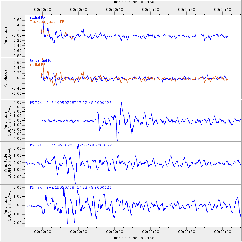
TSK Tsukuba, Japan - Earthquake Result Viewer
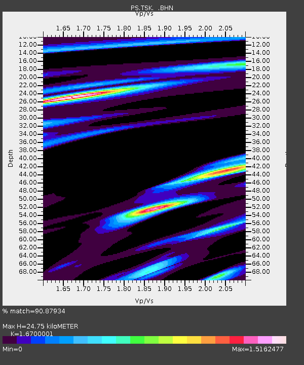
Earthquake location: Unimak Island Region, Alaska
Earthquake latitude/longitude: 53.6/-163.5
Earthquake time(UTC): 1995/07/08 (189) 17:15:28 GMT
Earthquake Depth: 33 km
Earthquake Magnitude: 5.8 MB, 5.7 MS, 5.5 UNKNOWN, 6.0 MW
Earthquake Catalog/Contributor: WHDF/NEIC
Network: PS Pacific21
Station: TSK Tsukuba, Japan
Lat/Lon: 36.21 N/140.11 E
Elevation: 350 m
Distance: 42.3 deg
Az: 269.154 deg
Baz: 47.398 deg
Ray Param: 0.073182404
Estimated Moho Depth: 24.75 km
Estimated Crust Vp/Vs: 1.67
Assumed Crust Vp: 6.24 km/s
Estimated Crust Vs: 3.737 km/s
Estimated Crust Poisson's Ratio: 0.22
Radial Match: 90.87934 %
Radial Bump: 379
Transverse Match: 87.5599 %
Transverse Bump: 400
SOD ConfigId: 6273
Insert Time: 2010-02-27 03:52:36.461 +0000
GWidth: 2.5
Max Bumps: 400
Tol: 0.001

Signal To Noise

ChannelStoNSTALTA
PS:TSK: :BHN:19950708T17:22:48.300012Z3.29490523.5634395E-71.0814998E-7
PS:TSK: :BHE:19950708T17:22:48.300012Z5.9009745.839561E-79.8959276E-8
PS:TSK: :BHZ:19950708T17:22:48.300012Z10.464681.2860335E-61.2289277E-7
Arrivals
Ps2.8 SECOND
PpPs9.9 SECOND
PsPs/PpSs13 SECOND