You are here: Home > Network List > II - Global Seismograph Network (GSN - IRIS/IDA) Stations List
> Station EFI Mount Kent, East Falkland Island > Earthquake Result Viewer
EFI Mount Kent, East Falkland Island - Earthquake Result Viewer

| Earthquake location: |
South Of Fiji Islands |
| Earthquake latitude/longitude: |
-23.0/-177.2 |
| Earthquake time(UTC): |
2013/05/23 (143) 17:19:04 GMT |
| Earthquake Depth: |
174 km |
| Earthquake Magnitude: |
7.4 MW, 6.6 MB, 7.4 MW |
| Earthquake Catalog/Contributor: |
NEIC PDE/NEIC PDE-W |
|
| Network: |
II Global Seismograph Network (GSN - IRIS/IDA) |
| Station: |
EFI Mount Kent, East Falkland Island |
| Lat/Lon: |
51.68 S/58.06 W |
| Elevation: |
110 m |
|
| Distance: |
88.6 deg |
| Az: |
147.052 deg |
| Baz: |
233.59 deg |
| Ray Param: |
0.04207833 |
| Estimated Moho Depth: |
37.0 km |
| Estimated Crust Vp/Vs: |
1.78 |
| Assumed Crust Vp: |
6.472 km/s |
| Estimated Crust Vs: |
3.641 km/s |
| Estimated Crust Poisson's Ratio: |
0.27 |
|
| Radial Match: |
86.842476 % |
| Radial Bump: |
400 |
| Transverse Match: |
68.18109 % |
| Transverse Bump: |
400 |
| SOD ConfigId: |
512894 |
| Insert Time: |
2013-09-14 15:58:20.858 +0000 |
| GWidth: |
2.5 |
| Max Bumps: |
400 |
| Tol: |
0.001 |
|
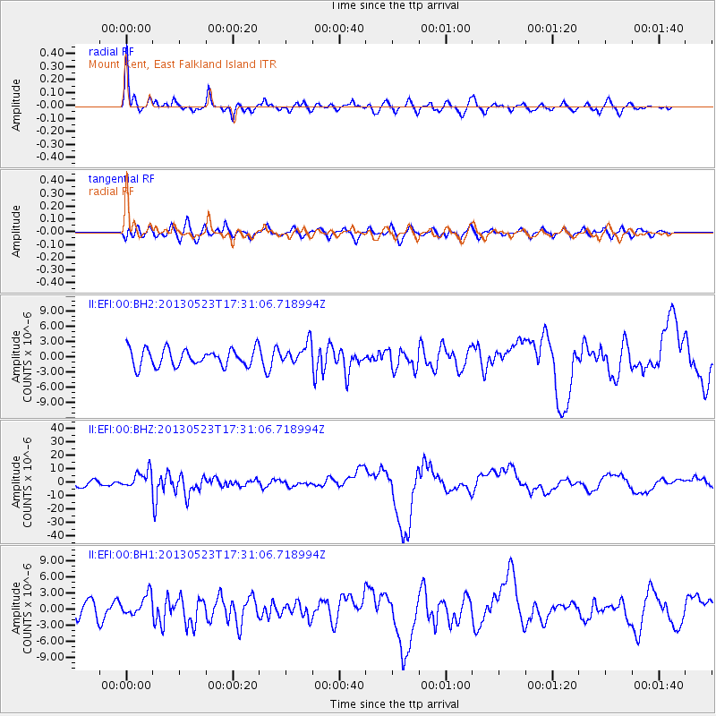
Signal To Noise
| Channel | StoN | STA | LTA |
| II:EFI:00:BHZ:20130523T17:31:06.718994Z | 3.112286 | 6.674005E-6 | 2.144406E-6 |
| II:EFI:00:BH1:20130523T17:31:06.718994Z | 1.2515305 | 1.9203894E-6 | 1.5344327E-6 |
| II:EFI:00:BH2:20130523T17:31:06.718994Z | 1.2186532 | 2.0674238E-6 | 1.6964824E-6 |
| Arrivals |
| Ps | 4.5 SECOND |
| PpPs | 16 SECOND |
| PsPs/PpSs | 20 SECOND |


